
Population 120 (2005)134 (2011) | Sovereign state United Kingdom Postcode district IP29 District St Edmundsbury | |
 | ||
Hawkedon is a village and civil parish in the St Edmundsbury district of Suffolk in eastern England. Located around 7 miles (11 km) south-south-west of Bury St Edmunds, the parish also contains the hamlet of Thurston End, and in 2005 had a population of 120. The majority of the village is classed as a conservation area.
Map of Hawkedon, Bury Saint Edmunds, UK
The village has a large number of medieval buildings and the 15th-century church, St Mary's is very unusual in that it is placed on the green. It is reputed to be the only church in Suffolk located in this way. It is a Grade I listed building, and includes a painted panel depicting St Dorothy and a square font with carved panels thought to date from the 12th-century.
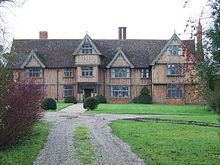
There are many other listed properties in the parish, notably the Grade I Swan Hall and Thurston End Hall (both fine timber-framed 16th-century houses). The village also has a 1935 listed K6 telephone box to the west of the pub. In 2010, Hawkedon History Group was formed to collate images and information about the village's past.
Although there are now no shops, there is a 15th-century pub called The Queen's Head (formerly known as the Queen Inn).