
Country United States County Alcona Time zone EST (UTC-5) Area 158 ha Population 477 (2013) | Elevation 623 ft (190 m) Area code(s) 989 Zip code 48740 Local time Friday 3:42 AM | |
 | ||
Weather -8°C, Wind NW at 2 km/h, 72% Humidity | ||
Harrisville michigan
Harrisville is a city in the U.S. state of Michigan and the county seat of Alcona County. The population was 493 at the 2010 census. The city is surrounded by Harrisville Township, but is administratively autonomous. Located on Lake Huron, it is an official Michigan Department of Natural Resources Harbor of Refuge.
Contents
- Harrisville michigan
- Map of Harrisville MI 48740 USA
- History
- Geography
- 2010 census
- 2000 census
- Major highways
- Bus
- Airport
- Government
- Notable residents
- Media
- References
Map of Harrisville, MI 48740, USA
History
The place was first known as Davison's Mill after Crosier Davison, who in partnership with Simeon Holden, had purchased land and water power rights here in 1854. Benjamin Harris and his sons, Levi and Henry, of West Bloomfield, New York bought out the partners. A post office established on September 16, 1857 was named Harrisville, with Levi as the first postmaster.
The Harris sold out to Weston, (George L.) Colwell & Company, who had H.G. Rothwell plat the community in 1870. Harrisville was incorporated as a village in 1887 and as a city in 1905.
Geography
According to the United States Census Bureau, the city has a total area of 0.61 square miles (1.58 km2), all land. It is considered to be part of Northern Michigan.
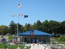
The city is on the western shore of Lake Huron and has a harbor for recreational boaters. The harbor is a center for salmon and trout fishing. It is also a designated "Harbor of Refuge" on Lake Huron by the US Coast Guard.
The town also boasts Harrisville State Park, which includes a wooded campground along the beach.
Sturgeon Point Light Station, a lighthouse and museum, is a few miles to the north, and is open to the public.
Harrisville is on the edge of Huron National Forest, which offers outdoor recreational opportunities such as hunting, swimming, cross-country skiing and trout fishing. The forest contains 330 miles (530 km) of hiking trails. The Huron and Manistee National Forests were separately designated, but were combined in 1945 for administrative purposes.
The Lake Huron beaches in and around Harrisville (including two state parks) have been recognized as being among the "top ten in Michigan." "Old-fashioned lake vacations abound on this pretty stretch of Lake Huron."
Harrisville is situated along the Lake State Railway, formerly the Detroit and Mackinac Railway (D&M). The D&M passenger depot is made of stone, which makes it one of two along the railway (the other being in Standish). It is privately maintained by local citizens as part of the municipality's historical legacy.
2010 census
As of the census of 2010, there were 493 people, 231 households, and 130 families residing in the city. The population density was 808.2 inhabitants per square mile (312.0/km2). There were 329 housing units at an average density of 539.3 per square mile (208.2/km2). The racial makeup of the city was 96.6% White, 0.6% African American, 1.0% Native American, 0.2% Asian, 0.6% from other races, and 1.0% from two or more races. Hispanic or Latino of any race were 2.4% of the population.
There were 231 households of which 18.2% had children under the age of 18 living with them, 42.4% were married couples living together, 11.7% had a female householder with no husband present, 2.2% had a male householder with no wife present, and 43.7% were non-families. 38.5% of all households were made up of individuals and 20.3% had someone living alone who was 65 years of age or older. The average household size was 1.96 and the average family size was 2.55.
The median age in the city was 51.6 years. 16.4% of residents were under the age of 18; 5% were between the ages of 18 and 24; 20.2% were from 25 to 44; 29% were from 45 to 64; and 29.6% were 65 years of age or older. The gender makeup of the city was 45.0% male and 55.0% female.
2000 census
As of the census of 2000, there were 514 people, 239 households, and 131 families residing in the city. The population density was 831.2 per square mile (320.1/km²). There were 327 housing units at an average density of 528.8 per square mile (203.6/km²). The racial makeup of the city was 94.94% White, 2.14% African American, 0.39% Native American, 0.97% Asian, and 1.56% from two or more races. Hispanic or Latino of any race were 0.97% of the population.
There were 239 households out of which 18.4% had children under the age of 18 living with them, 44.4% were married couples living together, 8.4% had a female householder with no husband present, and 44.8% were non-families. 41.4% of all households were made up of individuals and 22.6% had someone living alone who was 65 years of age or older. The average household size was 1.92 and the average family size was 2.57.
In the city, the population was spread out with 16.0% under the age of 18, 7.4% from 18 to 24, 21.6% from 25 to 44, 25.9% from 45 to 64, and 29.2% who were 65 years of age or older. The median age was 48 years. For every 100 females there were 96.2 males. For every 100 females age 18 and over, there were 93.7 males.
The median income for a household in the city was $27,500, and the median income for a family was $34,286. Males had a median income of $23,625 versus $21,875 for females. The per capita income for the city was $16,983. About 9.3% of families and 13.6% of the population were below the poverty line, including 20.8% of those under age 18 and 6.5% of those age 65 or over.
Major highways
Bus
Airport
Harrisville City Airport is 2200 feet (671 m) in length; it is located on Walker Road. A larger public airport that serves the area and has nearly all weather capability is Oscoda-Wurtsmith Airport.
Government
(information as of May 2012)