
Country United States County Emmet Time zone EST (UTC-5) Population 1,207 (2013) | State Michigan Elevation 669 ft (204 m) ZIP codes 49737, 49740 Local time Thursday 8:53 AM | |
 | ||
Weather -3°C, Wind W at 8 km/h, 69% Humidity Points of interest Zorn Park, Harbor Springs Deer Park, West Wequetonsing Nature Pr | ||
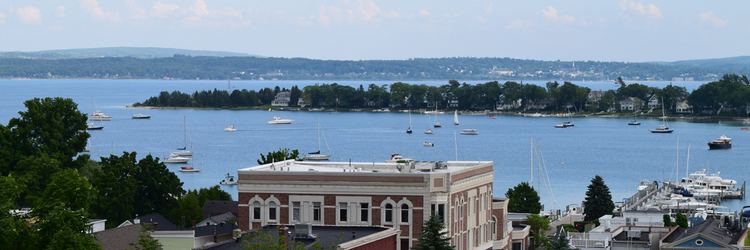
Driving harbor springs michigan
Harbor Springs is a city and resort community in Emmet County in the U.S. state of Michigan. The population was 1,194 at the 2010 census.
Contents
- Driving harbor springs michigan
- Map of Harbor Springs MI 49740 USA
- Relax amongst the trees in harbor springs michigan
- History
- Geography
- Climate
- 2010 census
- 2000 census
- Airports
- Highways
- Notable people
- References
Map of Harbor Springs, MI 49740, USA
Harbor Springs is in a sheltered bay on the north shore of the Little Traverse Bay on Lake Michigan. The Little Traverse Lighthouse is a historic lighthouse on the Harbor Point peninsula, which shelters the deepest natural harbor on the Great Lakes. M-119 connects with US 31 7 miles (11 km) east and south at Bay View, and Petoskey, which is 4 miles (6.4 km) away on the south side of the harbor.
The area is known for its historic summer resorts, such as Wequetonsing, which was founded by Illinois businessmen and lawyers Henry Stryker, III, and Henry Brigham McClure. They were both connected with the Jacob Bunn industrial dynasty of Illinois.
Relax amongst the trees in harbor springs michigan
History
The European-American settlement started with a mission by French Catholic Jesuits; they called this area L'Arbre Croche, meaning Crooked Tree. In 1847, L'Arbre Croche had the largest concentration of Native Americans in Michigan. French traders renamed the area Petit Traverse, or Little Traverse, when they arrived in the area. After more settlers came to the area from the eastern United States, they changed the name of the village to Harbor Springs, incorporating it in 1880.
The federally recognized Little Traverse Bay Bands of Odawa Indians are descendants of the numerous Odawa bands that historically occupied this area. They have their tribal offices in Harbor Springs, and a gaming resort in Petoskey. Their reservation lands encompasses approximately 336 square miles (870 km2) of land in Charlevoix and Emmet counties.
One of the city's more prominent European-American residents was Ephraim Shay (1839–1916), known for his invention of the Shay locomotive. The hexagonal-shaped house he built in downtown Harbor Springs still stands today and is listed on the National Register of Historic Places. The local elementary school is named after him.
Another building of interest is the Douglas House on the shore of Lake Michigan. Designed by noted architect Richard Meier and completed in 1973, this house is one of 150 structures listed in 2007 as America's Favorite Architecture by the American Institute of Architects.
Harbor Springs was the location of the Club Ponytail, a famous music hall destroyed by fire in 1969.
Geography
According to the United States Census Bureau, the city has a total area of 1.30 square miles (3.37 km2), all of it land. Harbor Springs has a lot to offer during the summer months, including beaches, sailing schools, marinas, multiple golf courses, bike paths, hiking trails, ice cream shops, candy stores, coffee shops and various summer vacation communities. In the winter months the two ski resorts Nub's Nob and Boyne Highlands offer over 678 acres of skiable terrain as well as terrain parks and various trails for snow shoeing & cross-country skiing. When Little Traverse Bay freezes over in the winter months, many people venture out on the ice for ice fishing and ice boating.
Harbor Springs is a few miles from neighboring Petoskey, Michigan, on the other side of the bay. It offers a wider variety of activities, including a multiplex movie theater, a thriving downtown area of its own, and several big-box stores.
Climate
The climate is described as Humid Continental by the Köppen Climate System, abbreviated as Dfb.
2010 census
As of the census of 2010, there were 1,194 people, 558 households, and 294 families residing in the city. The population density was 918.5 inhabitants per square mile (354.6/km2). There were 1,122 housing units at an average density of 863.1 per square mile (333.2/km2). The racial makeup of the city was 92.0% White, 0.3% African American, 0.8% Native American, 4.8% Asian, 0.1% Pacific Islander, 0.1% from other races, and 2.0% from two or more races. Hispanic or Latino of any race were 0.7% of the population.
There were 558 households of which 19.4% had children under the age of 18 living with them, 38.4% were married couples living together, 10.0% had a female householder with no husband present, 4.3% had a male householder with no wife present, and 47.3% were non-families. 43.7% of all households were made up of individuals and 23.1% had someone living alone who was 65 years of age or older. The average household size was 1.93 and the average family size was 2.66.
The median age in the city was 55.8 years. 15.7% of residents were under the age of 18; 4.9% were between the ages of 18 and 24; 14.7% were from 25 to 44; 32.6% were from 45 to 64; and 32.2% were 65 years of age or older. The gender makeup of the city was 43.8% male and 56.2% female.
2000 census
As of the census of 2000, there were 1,567 people, 683 households, and 383 families residing in the city. The population density was 1,208.9 per square mile (465.4/km²). There were 1,086 housing units at an average density of 837.8 per square mile (322.5/km²). The racial makeup of the city was 91.70% White, 0.19% African American, 5.87% Native American, 0.19% Asian, and 2.04% from two or more races. Hispanic or Latino of any race were 0.57% of the population.
There were 683 households out of which 23.0% had children under the age of 18 living with them, 46.0% were married couples living together, 7.8% had a female householder with no husband present, and 43.8% were non-families. 39.4% of all households were made up of individuals and 18.0% had someone living alone who was 65 years of age or older. The average household size was 2.14 and the average family size was 2.88.
In the city, the population was spread out with 20.4% under the age of 18, 4.6% from 18 to 24, 22.8% from 25 to 44, 28.3% from 45 to 64, and 23.8% who were 65 years of age or older. The median age was 47 years. For every 100 females there were 81.6 males. For every 100 females age 18 and over, there were 74.4 males.
The median income for a household in the city was $35,341, and the median income for a family was $46,750. Males had a median income of $29,236 versus $27,167 for females. The per capita income for the city was $21,876. About 5.3% of families and 6.8% of the population were below the poverty line, including 6.5% of those under age 18 and 9.8% of those age 65 or over.