
Country United States GNIS feature ID 1511641 Zip code 99343 Local time Wednesday 2:43 PM | Time zone Pacific (PST) (UTC-8) Elevation 123 m Area code Area code 509 | |
 | ||
Weather 18°C, Wind SW at 18 km/h, 53% Humidity | ||
Hanford was a small agricultural community in Benton County, Washington, United States. It was depopulated in 1943 along with the town of White Bluffs in order to make room for the nuclear production facility known as the Hanford Site. The town was located in what is now the "100F" sector of the site.
Map of Hanford, WA 99343, USA
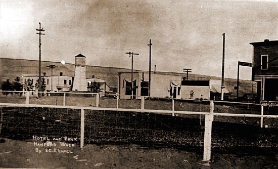
The original town, named for the judge and irrigation company president Cornelius Hanford, was settled in 1907 on land bought by the local power and water utility. In 1913, the town had a spur railroad link to the transcontinental Chicago, Milwaukee and St. Paul Railway, also known as "the electric railroad". By 1925 the town was booming thanks to high agricultural demand, and it boasted a hotel, bank, and its own elementary and high schools.
The town was condemned by the Federal government to make way for the Hanford site. Residents were given a thirty-day eviction notice on March 9, 1943. Most buildings were destroyed, with the notable exception of the high school. It was used during World War II as the construction management office.
The former Hanford High School still stands today, marred by its use during the years for SWAT practice, and can be seen from the Hanford tour bus operated by the U.S. government. It is now protected as part of the Manhattan Project National Historical Park.