
Country United States GNIS feature ID 0359058 Zip code 96716 Area code 808 | State Hawaii FIPS code 15-11800 Elevation 28 m Population 2,638 (2010) | |
 | ||
Time zone Hawaii-Aleutian (UTC-10) Area 259 ha (233 ha Land / 26 ha Water) | ||
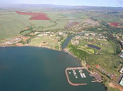
Hanapepe (literally, "crushed bay" in Hawaiian perhaps so called due to landslides in the area) is a census-designated place (CDP) in Kauai County, Hawaii, United States. The population was 2,638 at the 2010 census.
Contents
Map of Hanapepe, HI, USA
History
Hanapepe was one of the locations visited by the United States Exploring Expedition under Charles Wilkes; the expedition arrived in Hawaii in late September, 1840, and spent some time in the islands. It is one of the few towns on the island that was not created by the sugarcane plantations. In the 1920s, a deadly labor battle, later dubbed the Hanapepe Massacre, occurred in Hanapepe.
On August 27, 1980, Douglas Kenney, a co-writer of National Lampoon's Animal House, fell thirty feet to his death from the Hanapepe Lookout.
Hanapepe is the headquarters location for the ice cream company Lappert's Hawaii, as well as home to the westernmost bookstore in the United States, The Bookstore - Talk Story. It was the inspiration for Kokaua Town, the fictional hometown of the main characters in the Disney animated film Lilo & Stitch and its related franchise (the town was not named until Lilo & Stitch: The Series).
Geography
Hanapepe is located at 21°54′59″N 159°35′25″W (21.916392, -159.590414).
According to the United States Census Bureau, the CDP has a total area of 1.0 square mile (2.6 km2), of which 0.9 square miles (2.3 km2) is land, and 0.1 square miles (0.26 km2) (10.31%) is water.
Demographics
As of the census of 2000, there were 2,153 people, 706 households, and 533 families residing in the CDP. The population density was 2,469.8 people per square mile (955.5/km²). There were 757 housing units at an average density of 868.4 per square mile (336.0/km²). The racial makeup of the CDP was 16.0% White, 0.1% African American, 0.3% Native American, 48.6% Asian, 8.5% Pacific Islander, 0.2% from other races, and 26.3% from two or more races. Hispanic or Latino of any race were 8.6% of the population.
There were 706 households out of which 41.8% had children under the age of 18 living with them, 57.2% were married couples living together, 12.3% had a female householder with no husband present, and 24.4% were non-families. 19.8% of all households were made up of individuals and 8.6% had someone living alone who was 65 years of age or older. The average household size was 3.05 and the average family size was 3.54.
In the CDP the population was spread out with 32.0% under the age of 18, 6.5% from 18 to 24, 29.4% from 25 to 44, 20.1% from 45 to 64, and 12.1% who were 65 years of age or older. The median age was 35 years. For every 100 females there were 103.3 males. For every 100 females age 18 and over, there were 98.9 males.
The median income for a household in the CDP was $44,112, and the median income for a family was $50,750. Males had a median income of $30,039 versus $24,224 for females. The per capita income for the CDP was $17,043. About 5.8% of families and 6.6% of the population were below the poverty line, including 7.7% of those under age 18 and 10.8% of those age 65 or over.