
Country United States Elevation 12 ft (4 m) FIPS code 15-10750 Population 3,970 (2010) | State Hawaii Area code(s) 808 Zip code 96712 | |
 | ||
Time zone Hawaii-Aleutian (UTC-10) Weather 27°C, Wind NW at 14 km/h, 75% Humidity Points of interest Haleiwa Ali'i Beach Park, Kaiaka Bay Beach Park, Pua`ena Point Beach Park, Hale'iwa Beach Park, Haleiwa Beach | ||
Dat cajun guy new orleans food truck in haleiwa hawaii
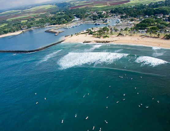
Haleʻiwa is a North Shore community and census-designated place (CDP) in the Waialua District of the island of Oʻahu, City and County of Honolulu. Haleʻiwa is located on Waialua Bay, the mouth of Anahulu Stream (also known as Anahulu River). A small boat harbor is located here, and the shore of the bay is surrounded by Haleʻiwa Beach Park (north side) and Haleʻiwa Aliʻi Beach Park (south side). Further west from the center of town is Kaiaka State Recreation Area on Kiaka Point beside Kaiaka Bay. As of the 2010 census, the CDP had a population of 3,970. It is the largest commercial center on the North Shore of the island. Its old plantation town character is preserved in many of the buildings, making this a popular destination for tourists and residents alike, visiting surfing and diving sites along the north shore.
Contents
- Dat cajun guy new orleans food truck in haleiwa hawaii
- Map of Haleiwa HI 96712 USA
- Giovanni s shrimp truck haleiwa hawaii
- Geography
- Military
- Demographics
- Education
- Attraction
- References
Map of Haleiwa, HI 96712, USA
The U.S. postal code for Haleʻiwa, including Kawailoa, is 96712.
Giovanni s shrimp truck haleiwa hawaii
Geography
Haleʻiwa is located at 21°35'24" North, 158°6'50" West (21.590050, -158.113928), southwest along Kamehameha Highway (State route 83) from Pūpūkea. At Haleʻiwa, Kamehameha Highway becomes state route 99 (at the traffic circle known as "Weed Circle"), which runs eastward up across the Oʻahu central plateau to Wahiawā. A new bypass route (Joseph P. Leong Highway) avoids both the traffic circle and Haleʻiwa, extending state route 83 to just north of Haleʻiwa town. Haleʻiwa Road and both Kaukonahua Road and Waialua Beach Road from Weed Circle go south and southwest into Waialua across Paukauila Stream.
"The historic Rainbow Bridge over the Anahulu River marks the northern entrance to old Haleiwa Town. There you will find small shops, eateries and many galleries. Two beach parks surround the small boat harbor located in Waialua Bay, Haleiwa Beach Park located to the north and Haleiwa Alii Beach Park located to the south."
According to the United States Census Bureau, the CDP has a total area of 3.0 square miles (7.7 km2). 2.3 square miles (5.9 km2) of it is land, and 0.69 square miles (1.8 km2) of it is water. The total area is 23.67% water.
In 1898 a businessman named Benjamin Dillingham opened a hotel in the North Shore area and named it Haleʻiwa. In the Hawaiian language, hale means "house", and the ʻiwa is a frigatebird.
According to Hawaii Town 1984 Haleiwa became a State Historic, Cultural and Scenic District in Hawaii.
Military
The 16th Coast Artillery's Battery F was assigned to four 8-inch M1888 railway guns that were located nearby on specially made spurs. These railway guns were soon dismounted and designated as Battery Kahuku. On December 7, 1941, two P-40B fighters, piloted by George Welch and Kenneth M. Taylor, managed to scramble against the Japanese attack on Pearl Harbor took off from the now-abandoned Haleʻiwa Airfield.
Demographics
As of the 2000 Census, there were 2,225 people, 770 households, and 525 families residing in the CDP. The population density was then 469.4/km² (1,218.1/mi²). There were 867 housing units at an average density of 474.6 per square mile (182.9/km²). The racial makeup of the CDP was 24.63% White, 0.49% Black or African American, 0.31% Native American, 28.85% Asian, 9.98% Pacific Islander, 0.81% from other races, and 34.92% from two or more races. 10.29% of the population were Hispanic or Latino of any race.
There were 770 households out of which 28.8% had children under the age of 18 living with them, 45.7% were married couples living together, 14.4% had a female householder with no husband present, and 31.7% were non-families. 24.4% of all households were made up of individuals and 8.7% had someone living alone who was 65 years of age or older. The average household size was 2.88 and the average family size was 3.46.
In the CDP the population was spread out with 26.2% under the age of 18, 9.7% from 18 to 24, 27.2% from 25 to 44, 24.6% from 45 to 64, and 12.3% who were 65 years of age or older. The median age was 36 years. For every 100 females there were 103.6 males. For every 100 females age 18 and over, there were 101.1 males.
The median income for a household in the CDP was $39,643, and the median income for a family was $48,553. Males had a median income of $31,750 versus $25,163 for females. The per capita income for the CDP was $16,504. 17.6% of the population and 15.0% of families were below the poverty line. Out of the total population, 26.2% of those under the age of 18 and 6.7% of those 65 and older were living below the poverty line.
Education
The Hawaii Department of Education operates public schools. Haleiwa Elementary School and Sunset Beach Elementary School are in the CDP.
Attraction
Matsumoto's Shave Ice, a local island favorite, is located in Haleiwa town and sells Oahu's most popular shave ice. It has been open for over half a century now, and is open daily Monday to Sunday from 8:30AM to 6:00PM.
"Haleiwa Beach Park provides a plethora of possibilities including surfing lessons which are offered year round by Uncle Bryan's Sunset Suratt Surf School and the North Shore Surf Girls and is walking distance from shopping, eating and sightseeing in historic Haleiwa Town."
For shell collectors, Haleiwa Beach Park is an excellent place to find rare Hawaiian sunrise shells.