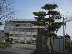
Population 6,287 (Aug 2013) | - Tree Japanese Zelkova Area 17 km² Local time Tuesday 8:32 PM | |
 | ||
Weather 0°C, Wind E at 14 km/h, 81% Humidity | ||
Hachirōgata (八郎潟町, Hachirōgata-machi) is a town located in Minamiakita District, Akita, Japan. As of August 2013, the town had an estimated population of 6,287 and a population density of 370 persons per km². The total area was 17.00 km². It is the smallest municipality in Akita Prefecture in terms of surface area.
Contents
- Map of Hachirogata Minamiakita District Akita Prefecture Japan
- Geography
- Neighboring municipalities
- History
- Economy
- Railway
- Highway
- References
Map of Hachirogata, Minamiakita District, Akita Prefecture, Japan
Geography
Hachirōgata is located in the coastal flatlands northeastern Akita Prefecture, bordered by the remnant of Lake Hachirōgata which lies in the west of the town. Lake Hachirōgata was the second largest lake in Japan until it was drained in a land reclamation project from 1957 to 1977.
Neighboring municipalities
History
The area of present-day Hachirōgata was part of ancient Dewa Province, dominated by the Satake clan during the Edo period, who ruled Kubota Domain under the Tokugawa shogunate. The village of Omogata was established in 1889, the town of Hitoichi in 1925. The two merged in 1956 to form the town of Hachirōgata. Efforts to merge the town with neighboring Gojōme and Ikawa failed to pass a referendum in 2005.
Economy
The economy of Hachirōgata is based on agriculture.
