
OS grid reference TF029359 Dialling code 01529 | Sovereign state United Kingdom Postcode district NG34 | |
 | ||
UK parliament constituency Sleaford and North Hykeham | ||
Haceby is a hamlet in the civil parish of Newton and Haceby (where the population is included) in the district of North Kesteven, Lincolnshire, England. It is situated 8 miles (13 km) east from Grantham, 8 miles south from Sleaford, and 1 mile (1.6 km) south from the A52 road.
Map of Haceby, Sleaford, UK
In the Domesday account the village is written as "Hazebi". The -by suffix is a Scandinavian word ending, for a place name based on a personal name. It is suggested that the origin is Farmstead or village of Haddr.
Haceby consists of a small number of houses, farm buildings, and the Grade I listed redundant St Barbara's Church. Although dedicated to St Barbara, it is also attributed to St Margaret or to both saints.
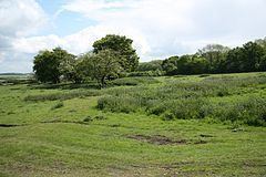
Earthworks to the west of the village are still visible as the remains of a Roman Villa. In 1818 a tessellated pavement and other Roman remains were discovered.
The village's war memorial is found combined with that of Newton, in Newton's St Botolph Church.