
Length 296 km Country Tajikistan | Source Yashilkul Cities Khorugh | |
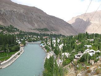 | ||
The Gunt River is a river in the south of Tajikistan. Its source, Lake Yashilkul, is situated at the edge of the Alichur Pamir, a high plateau or pamir at an elevation of 3720m. The city of Khorog is located at the confluence of the Gunt with the Panj River (the latter forming the border between Tajikistan and Afghanistan and also being known as Amu Darya, or in antiquity the Oxus).
Map of Gunt River, Tajikistan
The Gunt, and its affluent Shahdara, power the Pamir I power plant. River flow is very seasonal, low in Winter, but high in July and August due to water from melting snow. Its width varies from 10 to 50 meters and it is up to 1.5 meters deep. Due to the mountainous terrain, the rivercourse is very fast, over 2 m/s at times. Its bed is rocky, and the banks are steep and precipitous. Often the stream occupies the whole river valley, but sometimes it divides into several courses.