
- location Tinnet Krat Length 176 km Mouth elevation 0 | Bridges Randersbro | |
 | ||
- average 32.4 m/s (1,144 cu ft/s) Similar | ||
Gudenå or Gudenåen ([ˈɡuˀðn̩ˌɔːˀn̩]), is Denmark's longest river and runs through the central parts of the Jutlandic peninsula. An anglicized version of the name often seen is 'The River Guden'.
Map of Guden%C3%A5, Denmark
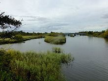
Gudenåen has its spring in Tinnet Krat, Vejle Municipality (between Nørre Snede and Tørring-Uldum) and flows a total of 176 kilometres (109 mi) to Randers Fjord in Randers, on a northward course which takes it through the central parts of Jutland. On its way, the river traverses the relatively high lying region of Søhøjlandet, through the lakes of Naldal Sø, Vestbirk Sø, Mossø, Gudensø, Rye Mølle Sø, Birksø, Julsø, Borre Sø, Brassø, Silkeborg Langsø and Sminge Sø before it empties in Randers Fjord; a long inlet of the Kattegat sea. It is fed by numerous streams and wetlands along the way.
Gudneåen came into existence some 15,000 years ago, at the end of the last Ice Age, when melting ice and glacial streams carved out its bed. The river shelters many species of animals and parts of its run, is to be protected under the regulations of Natura 2000.