
Postcode(s) 2669 Postal code 2669 | ||
 | ||
Location 432 km (268 mi) W of Sydney | ||
Gubbata is a locality in the Central West region of New South Wales. The locality is in the Bland Shire local government area 432 kilometres (268 mi) west of the state capital, Sydney.
Map of Gubbata, Kikoira NSW 2669, Australia
As the town was surveyed and only partially settled, the native scrub in the township reserve was left largely intact while around the town site was cleared for agriculture. This remnant area is the basis of the Gubbata Nature Reserve. The reserve is dominated by pointed mallee, congoo mallee and yorrel, Some spinifex and scrub cypress are also present. "The reserve is managed to maintain the sample of mallee habitats in an area that is largely cleared, which requires minimal visitation."
Gubbata's highest recorded temperature is 46.2°C and its lowest -4.8 °C. Rainfall is between 30 millimetres (1.2 in) and 40 millimetres (1.6 in) year round., and an altitude of about 204 metres (669 ft) above sea level.
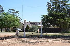
Gubbata is on the Naradhan Railway Line. The station opened 11 Feb 1929 and closed to passengers 4 May 1975.
Mines in the area include: The Blairgowrie Mine is an underground gold mine, and the Gubbata Mine is an underground gold mine just off the Naradhan Road :