
Country Brazil Area 24,856 km² Team Guajará Esporte Clube | Time zone BRT-1 (UTC-4) Local time Saturday 1:42 AM | |
 | ||
Weather 24°C, Wind N at 6 km/h, 91% Humidity | ||
Guajará-Mirim is a municipality in the Brazilian state of Rondônia. It is located at an altitude of 128 meters. Its population was 46,632 (2015) and its area is 24,856 km².
Contents
Map of Guajar%C3%A1-Mirim, State of Rond%C3%B4nia, Brazil
Location
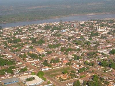
Guajará-Mirim lies along the Mamoré River, just across the Bolivian border town of Guayaramerín. It was once the southern terminus of the Estrada de Ferro Madeira-Mamoré (the Madeira-Mamoré Railway), which was inaugurated in 1912. It is the seat of the Roman Catholic Diocese of Guajará-Mirim.
Conservation
The municipality contains the 22,540 hectares (55,700 acres) Traçadal Biological Reserve, a strictly protected area that was created in 1990. It contains 2.33% of the 216,568 hectares (535,150 acres) Guajará-Mirim State Park, created in 1990. It contains the 46,438 hectares (114,750 acres) Rio Ouro Preto Biological Reserve, created in 1990. It contains 73.45% of the 204,632 hectares (505,660 acres) Rio Ouro Preto Extractive Reserve, also created in 1990. The municipality contains 47.5% of the 146,400 hectares (362,000 acres) Rio Cautário State Extractive Reserve, created in 1995. It contains the 73,818 hectares (182,410 acres) Rio Cautário Federal Extractive Reserve, created in 2001.