
Population 342 (2006 census) Postcode(s) 6254 Founded 1889 Local time Friday 9:43 AM | Established 1889 State electorate(s) Blackwood-Stirling Postal code 6254 | |
 | ||
Location 250 km (155 mi) S of Perth Weather 18°C, Wind E at 18 km/h, 60% Humidity Lga Shire of Bridgetown-Greenbushes | ||
Greenbushes is a timber and mining town located in the South West region of Western Australia.
Contents
Map of Greenbushes WA 6254, Australia
History
Greenbushes was founded as a mining town in 1888 following a surveyor's discovery of tin in 1886. Greenbushes was named after the bright green bushes that contrasted against the grey eucalyptus trees. The railway from Donnybrook to Bridgetown opened in 1898, with Greenbushes station located approximately six kilometres north of the main townsite. The area surrounding the train station was renamed North Greenbushes to reduce confusion.
The town experienced a period of economic boom until the international price of tin slumped in 1893, which caused the Greenbushes industry to collapse. By 1913, approximately one quarter of Greenbushes' inhabitants were working in the timber industry, which was established shortly after the first mine.
Industry
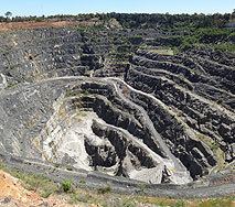
Greenbushes' two major industries are mining, producing tantalite concentrates, lithium minerals, tin metal and kaolin; and timber milling. Agriculture, viticulture, tourism and art galleries are also part of Greenbushes' industry.
The Greenbushes mine, located to the south of the town, has produced lithium concentrate since 1985.