
Max. length 11 kilometres (6.8 mi) Surface elevation 595 m Length 11 km Shore length 44.09 km | References NVE Area 22.63 km² Width 4.5 km Basin countries Norway, Sweden | |
 | ||
Location Hemnes, Norway and Västerbotten, Sweden Max. width 4.5 kilometres (2.8 mi) Surface area 22.63 km (8.74 sq mi)
(18.67 km or 7.21 sq mi in Norway) Reference Norwegian Water Resources and Energy Directorate | ||
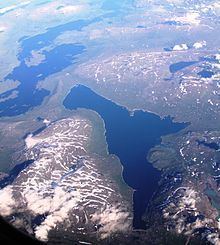
Gresvatnet or Grasvatnet (Southern Sami: Graesiejaevrie) is a lake on the border between Norway and Sweden. Most of the lake lies in the municipality of Hemnes in Nordland county (Norway) and then a small portion crosses the border into Storuman Municipality in Västerbotten county (Sweden). The lake lies about 25 kilometres (16 mi) east of the village of Korgen, and just a few kilometres northeast of the mountain Oksskolten and the Okstindbreen glacier.
Map of Grasvatnet, 8643 Bjerka, Norway
References
Grasvatnet Wikipedia(Text) CC BY-SA