
Crosses Clarence River Piers in water 7 concrete Clearance below 3.4 m Location Grafton Material Steel | Design Bascule bridge Opened 19 July 1932 Bridge type Bascule bridge Body of water Clarence River | |
 | ||
Carries Motor vehicles, railway line, water supply, pedestrians Locale Grafton, New South Wales, Australia Maintained by Roads and Maritime Services, NSW Government Similar Harwood Bridge, Denison Bridge, Nowra Bridge, Martin Bridge, Mooney Mooney Bridge | ||
Grafton Bridge is a bascule bridge which spans the Clarence River in Grafton in New South Wales, Australia.
Contents
- Map of Grafton Bridge Grafton NSW 2460 Australia
- Design and features
- Legend
- Additional crossing of the Clarence River
- References
Map of Grafton Bridge, Grafton NSW 2460, Australia
Design and features
The upper level of the bridge supports a two way road for traffic via Bent Street (Summerland Way), and its lower level supports a rail bridge that carries the North Coast railway line, a water main, and footbridges on either side.
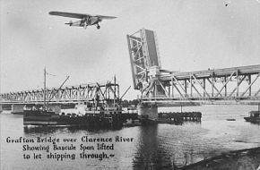
A bridge over the Clarence River in Grafton was first conceived in 1915. The original design called for a railway bridge with a footway, but in 1922 the design was changed to accommodate vehicular traffic as well. There is provision for a second track across the bridge but at this time it is being used as an easement for a water main. The Grafton Bridge was built by Dorman Long and opened in 1932 by the Governor-General of Australia, Sir Isaac Isaacs.
The bascule span was operational from its opening in 1932 until 1969. The bascule can no longer be raised due to an added water main. With the decline in shipping along the Clarence River, the opening span was sealed shut and it can no longer be opened.
Legend
Local legend has it that the blind corner on the northern end of bridge is because the roadway across the top of the bridge was originally intended to connect with Pound Street. According to the legend, a local councillor of the time owned a hotel on Fitzroy Street and wouldn't support building the bridge until the design was amended to connect with Fitzroy Street, directing traffic past his establishment, hence the unique kink in the northern roadway ramp. Contemporary news reports suggest that public opinion favoured the Fitzroy St approach eventually chosen, as opposed to a possible Pound St approach, as a matter of cost and so as to direct visitors to Grafton's main street rather than "through a lot of backyards."
Regardless of the truth of the legend, a more practical explanation for the kinks either side of the bridge is that the roadway has to clear the railway line below it, necessitating the bends in the bridge. The bends themselves present something of a dangerous situation for wide vehicles attempting to cross the bridge, and for travellers unaccustomed to the nuisance, which locals navigate at some speed, since the high iron sides of the narrow bridge obscure vision and threaten to prevent traffic flow if encountered by the vehicle. As a result of this, it is often necessary for smaller vehicles to stop prior to the bends to make way for larger vehicles which are unable to negotiate the bends while remaining in their own lane.
Additional crossing of the Clarence River
In 2002, the Government of New South Wales commissioned a study into an additional crossing, released in early 2003.
In October 2008, federal, state and local government representatives inspected the bridge, together with officials from Roads and Maritime Services (RMS). It was claimed that the existing bridge was not coping with the increasing volume of traffic. Estimates of replacing the bridge were in the range of A$100 million. In December 2012, RMS announced that a preferred option of an additional crossing of the Clarence River had been identified and went on public display for comment. RMS also announced that a final decision is expected during 2013.