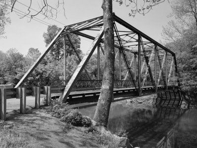
Carries Governor's Bridge Road Constructed by unknown Width 4.14 m | Total length 32 m Design Truss bridge | |
 | ||
Owner Maryland State Highway Administration Similar Queen Anne Bridge, Bollman Truss Railroad, Colville Covered Bridge, Airtight Bridge, Governor Thomas Johnson | ||
Governor's Bridge is an historic single-lane bridge over the Patuxent River near Bowie, Maryland. The river marks the boundary between Prince George's and Anne Arundel counties. A bridge has been located on this site since the mid-18th century.
Contents
Although a common bridge type, the current Governor's Bridge is one of only two surviving truss bridges in Prince George's County.
History
Three bridges have stood on this site.
The first bridge was constructed by Governor Samuel Ogle to travel between his mansion in Collington and the state capital in Annapolis.
By 1817, the first bridge had been damaged beyond repair or destroyed and a ford was being used to traverse the river at the site. On February 4, 1817, the State of Maryland commissioned Joseph N. Stockett and James Sanders of Anne Arundel County to build a new Governor's Bridge.
Current bridge
The current truss bridge was constructed in 1912.
The bridge was repaired in 2014 after structural deficiencies were discovered during a routine inspection. It was closed in May 2013, underwent major repairs starting in January 2014, and reopened in March 2014.
The bridge closed March 30, 2015, after contractors inspected the bridge and determined it required emergency repairs. It is scheduled to reopen in 2019.
