
Width 11.5 km (7.15 mi) Highest point Jærmannburet Elevation 99 m Municipality Aukra | Length 10.5 km (6.52 mi) Highest elevation 99 m (325 ft) Area 46.5 km² | |
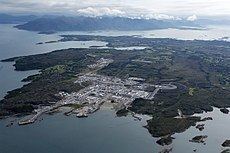 | ||
Gossa (dative: Gossen) is an island in Aukra Municipality in Møre og Romsdal county, Norway. The island encompasses most of the municipality and has a ferry connection from Aukrasanden across the Julsundet strait to Hollingen on the mainland. About 80% of the municipal population (about 2,500 people) is located on the island.
Map of Gossa, 6480 Aukra, Norway
The 46.5-square-kilometre (18.0 sq mi) island is flat and swampy, but it is well cultivated by farmland wherever possible. There are also some planted forests. The highest point on the island is the 99-metre (325 ft) tall Jærmannburet. The largest population centers on the island are Aukrasanden and Varhaugvika on the southeastern side, and Røssøyvågen is located on the west side. Aukra Auto runs bus service on the island.
The gas from the Ormen Lange gas field is brought ashore at Nyhamna on the northeastern shore. Here it is processed and pumped through the world's longest underwater pipeline, the Langeled pipeline, to Easington in the United Kingdom.