
- elevation 7,239 ft (2,206 m) Length 198 km Mouth Snake River | - elevation 4,137 ft (1,261 m) Basin area 2,901 km² Country United States of America | |
 | ||
- location Cassia Division of the Sawtooth National Forest, Cassia County, Idaho - location near Burley, Cassia County, Idaho | ||
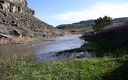
Goose Creek is a 123-mile (198 km) long tributary of the Snake River. Beginning at an elevation of 7,239 feet (2,206 m) in the Cassia Division of the Sawtooth National Forest in southwestern Cassia County, Idaho, it flows south into Elko County, Nevada and loops back around into Cassia County, briefly crossing Box Elder County, Utah in the process. It is impounded by Oakley Dam several miles south of Oakley, Idaho, forming Lower Goose Creek Reservoir. All of the creek's water is stored for irrigation, so its channel from the reservoir to its mouth near Burley, Idaho is dry and largely obliterated by agriculture. Goose Creek has a 1,120-square-mile (2,901 km2) watershed. The California Trail followed Goose Creek from a point just north of the Idaho/Utah border southwest across northwestern Utah to Little Goose Creek in northeastern Elko County, Nevada.