
FIPS code 19-30675 Area 100 ha Zip code 50634 Local time Monday 6:09 PM | Time zone Central (CST) (UTC-6) GNIS feature ID 0456900 Elevation 258 m Population 749 (2013) Area code 319 | |
 | ||
Weather -3°C, Wind N at 23 km/h, 67% Humidity | ||
Police chief tased to raise funds kcrg tv9 10pm gilbertville iowa
Gilbertville is a city in Black Hawk County, Iowa, United States. The population was 712 at the 2010 census. It is part of the Waterloo–Cedar Falls Metropolitan Statistical Area.
Contents
- Police chief tased to raise funds kcrg tv9 10pm gilbertville iowa
- Map of Gilbertville IA USA
- History
- Geography
- Infrastructure
- Education
- Health
- 2010 census
- 2000 census
- In popular culture
- References
Map of Gilbertville, IA, USA
History
Gilbertville was platted in 1856.
Geography
Gilbertville is located at 42°25′2″N 92°12′50″W (42.417252, -92.213964).
According to the United States Census Bureau, the city has a total area of 0.40 square miles (1.04 km2), all of it land.
Tornado activity
Gilbertville-area historical tornado activity is above Iowa state average. It is 206% greater than the overall U.S. average.
On 5/15/1968, a category F5 (max. wind speeds 261-318 mph) tornado 22.7 miles away from the Gilbertville city center killed 5 people and injured 156 people and caused between $5,000,000 and $50,000,000 in damages.
On 8/26/1965, a category F4 (max. wind speeds 207-260 mph) tornado 8.1 miles away from the city center killed one person and injured 17 people and caused between $500,000 and $5,000,000 in damages.
Natural disasters The number of natural disasters in Black Hawk County (16) is greater than the US average (12). Major Disasters (Presidential) Declared: 15 Emergencies Declared: 1 Causes of natural disasters: Floods: 10, Storms: 10, Tornadoes: 4, Floods: 3, Heavy Rains: 2, Hurricane: 1, Tornado: 1, Winter Storm: 1 (Note: Some incidents may be assigned to more than one category).
Gilbertville races chart
White alone - 691 (97.1%) Hispanic - 12 (1.7%) Asian alone - 4 (0.6%) Two or more races - 4 (0.6%) American Indian alone - 1 (0.1%)Infrastructure
Hospitals/medical centers near Gilbertville
Beacon Of Hope Hospice (Hospital, about 8 miles away; Waterloo, IA) Ravenwood Nursing And Rehab Centre (Nursing Home, about 8 miles away; Waterloo, IA) Blakhawk CO Health CTR (Nursing Home, about 8 miles away; Waterloo, IA)
Notable locations in Gilbertville Gilbertville Wastewater Plant, Gilbertville Volunteer Fire Department, Gilbertville Police Department, Gilbertville Town Hall.
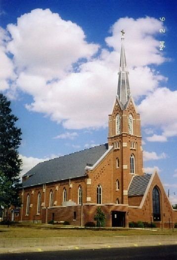
Church in Gilbertville Immaculate Conception Church.
Cemeteries Saint Mary's Cemetery, Saint Marys Catholic Cemetery.
Parks in Gilbertville Public Square Park, Veterans Park, Black Hawk County Park, Schmidt Park. Just west of town, the Gilbertvile Depot serves users of the Cedar Valley Nature Trail (CVNT).
Banks with branches in Gilbertville Farmers State Bank: , Gilbertville at 1306 5th Street, branch established on 2009/07/06. Info updated 2006/11/03: Bank assets: $374.6 mil, Deposits: $328.5 mil, headquarters in Waterloo, IA, positive income, Agricultural Specialization, 7 total offices, Holding Company: Fsb Financial Services, Inc
Education
Colleges/universities with over 2000 students nearest to Gilbertville Hawkeye Community College (about 6 miles; Waterloo, IA; Full-time enrollment: 3,189) University of Northern Iowa (about 15 miles; Cedar Falls, IA; FT enrollment: 10,923) Upper Iowa University (about 36 miles; Fayette, IA; FT enrollment: 3,144) Kirkwood Community College (about 45 miles; Cedar Rapids, IA; FT enrollment: 9,715) Northeast Iowa Community College-Calmar (about 56 miles; Calmar, IA; FT enrollment: 2,564) University of Iowa (about 63 miles; Iowa City, IA; FT enrollment: 24,313) Luther College (about 66 miles; Decorah, IA; FT enrollment: 2,470)
Private high school in Gilbertville
Don Bosco High School (Students: 440; Location: 405 16TH AVE; Grades: 9 - 12)
Private elementary/middle school in Gilbertville
Immaculate Conception-St. Joseph School (Students: 256; Location: 311 16TH AVE; Grades: KG - 8)
Health
Food Environment Statistics Number of grocery stores: 21 Black Hawk County:1.65 / 10,000 pop. State: 2.14 / 10,000 pop.
Number of supercenters and club stores: 3 Here:0.24 / 10,000 pop. Iowa:0.23 / 10,000 pop.
Number of convenience stores (no gas): 5 This county:0.39 / 10,000 pop. Iowa:0.43 / 10,000 pop.
Number of convenience stores (with gas): 59 Black Hawk County:4.64 / 10,000 pop. Iowa:5.55 / 10,000 pop.
Number of full-service restaurants: 94 This county:7.39 / 10,000 pop. State:8.01 / 10,000 pop.
Adult diabetes rate: Black Hawk County:7.9% Iowa:7.8%
Adult obesity rate: Black Hawk County:26.6% State:27.3%
Low-income preschool obesity rate: Here:14.0% State:14.5%
2010 census
As of the census of 2010, there were 712 people, 303 households, and 199 families residing in the city. The population density was 1,780.0 inhabitants per square mile (687.3/km2). There were 313 housing units at an average density of 782.5 per square mile (302.1/km2). The racial makeup of the city was 98.6% White, 0.1% Native American, 0.6% Asian, 0.1% from other races, and 0.6% from two or more races. Hispanic or Latino of any race were 1.7% of the population.
There were 303 households of which 28.4% had children under the age of 18 living with them, 52.8% were married couples living together, 8.6% had a female householder with no husband present, 4.3% had a male householder with no wife present, and 34.3% were non-families. 28.7% of all households were made up of individuals and 18.2% had someone living alone who was 65 years of age or older. The average household size was 2.35 and the average family size was 2.87.
The median age in the city was 42.7 years. 21.6% of residents were under the age of 18; 9.1% were between the ages of 18 and 24; 23% were from 25 to 44; 26.6% were from 45 to 64; and 19.8% were 65 years of age or older. The gender makeup of the city was 49.4% male and 50.6% female.
2000 census
As of the census of 2000, there were 767 people, 297 households, and 212 families residing in the city. The population density was 1,957.8 people per square mile (759.3/km²). There were 305 housing units at an average density of 778.5 per square mile (302.0/km²). The racial makeup of the city was 99.48% White, 0.13% African American, and 0.39% from two or more races. Hispanic or Latino of any race were 0.78% of the population.
There were 297 households out of which 35.0% had children under the age of 18 living with them, 61.3% were married couples living together, 7.7% had a female householder with no husband present, and 28.6% were non-families. 25.9% of all households were made up of individuals and 16.2% had someone living alone who was 65 years of age or older. The average household size was 2.58 and the average family size was 3.14.
In the city, the population was spread out with 27.1% under the age of 18, 8.3% from 18 to 24, 28.4% from 25 to 44, 19.6% from 45 to 64, and 16.6% who were 65 years of age or older. The median age was 38 years. For every 100 females there were 97.2 males. For every 100 females age 18 and over, there were 98.2 males.
The median income for a household in the city was $41,490, and the median income for a family was $47,917. Males had a median income of $31,458 versus $24,286 for females. The per capita income for the city was $18,367. About 4.0% of families and 4.0% of the population were below the poverty line, including 5.9% of those under age 18 and 7.6% of those age 65 or over.
In popular culture
Irish-English singer-songwriter, Gilbert O'Sullivan named his 2011 album Gilbertville after Gilbertville. The album cover features Exit 66 on Highway 380, which is the halfway point between Raymond (his real name) and Gilbertville.