
Length 85 km | ||
 | ||
Bridges Krämerbrücke, Hohenzollernbrücke | ||
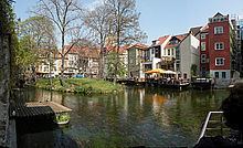
The Gera is a river in Thuringia, Germany, a right tributary of the Unstrut. It originates in the Thuringian Forest, west of Ilmenau. The Gera is formed in Plaue, by the confluence of the Wilde Gera and the Zahme Gera. It empties into the Unstrut in Straußfurt. The total length of the Gera (including Wilde Gera) is 85 km. The largest towns along the Gera are Arnstadt and Erfurt. The city Gera is not situated along the River Gera.
Map of Gera, Germany
Along its way, Gera River splits up and reunites multiple times. Branches of the Gera are:
The original name of Gera River was Erphes River (Latin for brown, muddy water), which survived in the name of Erfurt coming from “ford at Erphes River”.
References
Gera (river) Wikipedia(Text) CC BY-SA