
 | ||
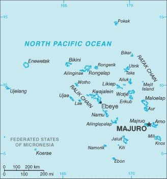
The Marshalls consist of 29 atolls and five isolated islands, which form two parallel groups—the "Ratak" (sunrise) chain and the "Ralik" (sunset) chain. The Marshalls share maritime boundaries with Micronesia and Kiribati. Two-thirds of the nation's population lives in Majuro and Ebeye. The outer islands are sparsely populated due to lack of employment opportunities and economic development.
Location: Oceania, group of atolls and reefs in the North Pacific Ocean, about one-half of the way from Hawaii to Papua New Guinea
Geographic coordinates: 9°00′N 168°00′E
Map references: Oceania
Area:
total: 181.3 km²
land: 181.3 km²
water: 0 km²
note: the archipelago includes the atolls of Bikini, Enewetak, Kwajalein, Majuro, Rongelap, and Utirik
Area - comparative: about the size of Washington, DC
Land boundaries: 0 km
Coastline: 370.4 km
Maritime claims:
territorial sea: 12 nm
contiguous zone: 24 nm
exclusive economic zone: 200 nm
Maritime boundaries:
Climate: topical; hot and humid; wet season from May to November; islands border typhoon belt
Terrain: low coral limestone and sand islands
Elevation extremes:
lowest point: Pacific Ocean 0 meters
highest point: unnamed location on Likiep 10 meters / 33 feet above sea level
Natural resources: coconut products, marine products, deep seabed minerals
Land use:
arable land: 11.11%
permanent crops: 44.44%
other: 44.44% (2011)
Irrigated land: 0 km² (2011)
Natural hazards: infrequent typhoons
Environment - current issues: inadequate supplies of potable water; pollution of Majuro lagoon from household waste and discharges from fishing vessels
Environment - international agreements:
party to: Biodiversity, Climate Change, Climate Change-Kyoto Protocol, Desertification, Hazardous Wastes, Law of the Sea, Ozone Layer Protection, Ship Pollution, Wetlands, Whaling
signed, but not ratified: none of the selected agreements
Geography - note: two archipelagic island chains of 30 atolls and 1,152 islands; Bikini and Enewetak are former US nuclear test sites; Kwajalein, the famous World War II battle ground, is now used as a US missile test range; the island city of Ebeye is the second largest settlement in the Marshall Islands, after the capital of Majuro, and one of the most densely populated locations in the Pacific.
Extreme points
This is a list of the extreme points of the Marshall Islands, the points that are farther north, south, east or west than any other location.