
Time zone CET/CEST (UTC+1/+2) Area 10.67 km² Local time Saturday 5:00 PM Dialling code 06765 | Elevation 300 m (1,000 ft) Postal codes 55490 Population 1,258 (31 Dec 2008) Postal code 55490 | |
 | ||
Weather 11°C, Wind E at 16 km/h, 51% Humidity | ||
Gemünden is an Ortsgemeinde – a municipality belonging to a Verbandsgemeinde, a kind of collective municipality – in the Rhein-Hunsrück-Kreis (district) in Rhineland-Palatinate, Germany. It belongs to the Verbandsgemeinde of Kirchberg, whose seat is in the like-named town.
Contents
- Map of 55490 GemC3BCnden Germany
- Location
- Constituent communities
- History
- Municipal council
- Mayor
- Coat of arms
- Culture and sightseeing
- Buildings
- Regular events
- Tourism
- Famous people
- References
Map of 55490 Gem%C3%BCnden, Germany
Location
The municipality lies at the southwest edge of the Soonwald, a heavily wooded section of the west-central Hunsrück. The village is found between Kirchberg to the northwest and Simmertal to the southeast. In Gemünden, the Lametbach empties into the Simmerbach, whereupon the combined stream is known down to its mouth into the river Nahe as the Kellenbach.
Constituent communities
The outlying centre of Panzweiler is part of Gemünden.
History
In 1304, Gemünden had its first documentary mention. This holding of the Counts of Sponheim was granted town rights along with its trappings, namely fortifications, a court and a market. Beginning in 1794, Gemünden lay under French rule. In 1815 it was assigned to the Kingdom of Prussia at the Congress of Vienna. Since 1946, it has been part of the then newly founded state of Rhineland-Palatinate.
Municipal council
The council is made up of 16 council members, who were elected by proportional representation at the municipal election held on 7 June 2009, and the honorary mayor as chairman.
The municipal election held on 7 June 2009 yielded the following results:
Mayor
Gemünden’s mayor is Dieter Kaiser, and his deputies are Dieter Bajohr, Didacus Kühnreich and Wolfgang Jonda.
Coat of arms
The German blazon reads: Schild geteilt, oben blau/gold geschacht, unten in Rot eine silberne Gewandschließe.
The municipality’s arms might in English heraldic language be described thus: Per pale chequy of eight azure and Or and gules an arming buckle argent.
The “chequy” pattern above the line of partition refers to the village’s former allegiance to the “Further” County of Sponheim. The lower half of the escutcheon is a reference to the Schmidtburg.
Culture and sightseeing
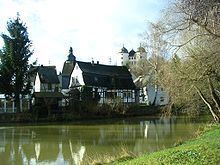
For its historic village centre and its valley location, locals call Gemünden the “Pearl of the Hunsrück” (Perle des Hunsrücks). Standing above the Simmerbach is Schloss Gemünden, a residential castle still used as a private home today. A good two kilometres south of Gemünden stands the Castle Koppenstein ruin on the Koppensteiner Höhe, a 555 m-high hilltop in the Soonwald. Five kilometres to the east is the Alteburgturm, a lookout tower on the Alteburg (mountain). Southwest of Gemünden is the Lützelsoon plateau.
Buildings
The following are listed buildings or sites in Rhineland-Palatinate’s Directory of Cultural Monuments:
Regular events
By longstanding tradition, the kermis is held on the last weekend in July and the fire brigade festival on the last weekend in August.
Tourism
A 4 km-long geological teaching path begins and ends in Gemünden. Twenty-three mineral groups from the Hunsrück-Nahe region are shown and explained on display boards. On the way, the path comes into contact with the Kaisergrube, the mine opened in 1873, where until 1969 slate was mined. Slate mining began in Gemünden in the early 19th century. On average, 600 t of slate was mined each year, and up to 35 miners were employed.
Gemünden is the starting point of the Schinderhannes-Soonwald-Radweg (cycle path) to Simmern.