Population 4,355 (2006 census) Postal code 3220 | Postcode(s) 3220 | |
 | ||
LGA(s) | ||
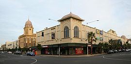
The Geelong city centre is a locality surrounded by the Geelong metropolitan area. It is also referred to as the Geelong CBD, Central Geelong, the Central Activities Area, and informally simply as "town" by locals. The suburb name is officially gazetted as Geelong.
Map of Geelong VIC, Australia
It is the oldest part of Geelong and includes many of the city's important landmarks such as the Geelong Town Hall, St. Mary of the Angels Basilica, the T & G Building, Johnstone Park and the Geelong Botanic Gardens, and the old Geelong Post Office.
The area is one of Geelong's major shopping districts, with the Westfield Geelong and Market Square Shopping Centre catering for shoppers. The opening of the major shopping centres have seen a decline in strip shopping on Moorabool Street, with many empty shops and few customers.
It is also a cultural area for the region, housing the Geelong Art Gallery and the Geelong Performing Arts Centre, as well as the Deakin University waterfront campus. A number of tourist attractions are also nearby, including Waterfront Geelong, Eastern Beach, and the National Wool Museum.
