
Country United States FIPS code 54-30364 Elevation 247 m Local time Friday 10:58 PM Area code 304 | Time zone Eastern (EST) (UTC-5) GNIS feature ID 1554543 Zip code 25085 Population 608 (2013) | |
 | ||
Weather 1°C, Wind NW at 16 km/h, 45% Humidity Area 4.222 km² (4.092 km² Land / 13 ha Water) | ||
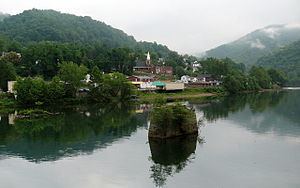
Gauley Bridge is a town in Fayette County, West Virginia, United States. The population was 614 at the 2010 census. The Kanawha River is formed at Gauley Bridge by the confluence of the New and Gauley Rivers. Two miles to the southeast of Gauley Bridge, in Glen Ferris, West Virginia, is Kanawha Falls, a popular stopping point on Midland Trail Scenic Highway.
Contents
- Map of Gauley Bridge WV 25085 USA
- Geography
- 2010 census
- 2000 census
- Transportation
- Notable residents
- References
Map of Gauley Bridge, WV 25085, USA
The community was named after a bridge over the Gauley River near the original town site. Gauley Bridge was close to the site of the Hawk's Nest incident, in which hundreds of lives were lost in the 1920s and 1930s.
Geography
Gauley Bridge is located at 38°10′04″N 81°11′49″W (38.167815, -81.197079).
According to the United States Census Bureau, the town has a total area of 1.63 square miles (4.22 km2), of which, 1.58 square miles (4.09 km2) is land and 0.05 square miles (0.13 km2) is water.
2010 census
As of the census of 2010, there were 614 people, 279 households, and 159 families residing in the town. The population density was 388.6 inhabitants per square mile (150.0/km2). There were 361 housing units at an average density of 228.5 per square mile (88.2/km2). The racial makeup of the town was 98.9% White, 0.3% Native American, and 0.8% from two or more races. Hispanic or Latino of any race were 0.5% of the population.
There were 279 households of which 23.3% had children under the age of 18 living with them, 34.8% were married couples living together, 16.5% had a female householder with no husband present, 5.7% had a male householder with no wife present, and 43.0% were non-families. 37.6% of all households were made up of individuals and 18.3% had someone living alone who was 65 years of age or older. The average household size was 2.20 and the average family size was 2.87.
The median age in the town was 43.5 years. 19.4% of residents were under the age of 18; 8.4% were between the ages of 18 and 24; 24.9% were from 25 to 44; 30% were from 45 to 64; and 17.3% were 65 years of age or older. The gender makeup of the town was 48.4% male and 51.6% female.
2000 census
As of the census of 2000, there were 738 people, 325 households, and 205 families residing in the town. The population density was 458.6 inhabitants per square mile (177.0/km2). There were 374 housing units at an average density of 232.4 per square mile (89.7/km2). The racial makeup of the town was 97.43% White, 0.68% African American, 0.68% from other races, and 1.22% from two or more races. Hispanic or Latino of any race were 1.36% of the population.
There were 325 households out of which 28.0% had children under the age of 18 living with them, 42.8% were married couples living together, 15.1% had a female householder with no husband present, and 36.9% were non-families. 31.4% of all households were made up of individuals and 13.8% had someone living alone who was 65 years of age or older. The average household size was 2.26 and the average family size was 2.80.
In the town, the population was spread out with 22.6% under the age of 18, 11.7% from 18 to 24, 26.3% from 25 to 44, 23.3% from 45 to 64, and 16.1% who were 65 years of age or older. The median age was 35 years. For every 100 females there were 88.3 males. For every 100 females age 18 and over, there were 86.0 males.
The median income for a household in the town was $22,500, and the median income for a family was $25,987. Males had a median income of $26,250 versus $19,688 for females. The per capita income for the town was $11,820. About 26.7% of families and 33.4% of the population were below the poverty line, including 49.7% of those under age 18 and 24.7% of those age 65 or over.
Transportation
U.S. Route 60, WV 16, and WV 39 all intersect in Downtown Gauley Bridge.