
Listing TuMP OS grid SX145780 Elevation 330 m | Prominence 57 m | |
 | ||
Topo map OS Landranger 200, Explorer 109 Similar Brown Willy, Rough Tor, Alex Tor, Kilmar Tor, Brown Gelly | ||
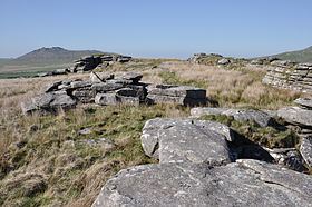
Garrow Tor is a bare, tor-crowned hill, 330 metres (1,080 ft) high, located on Garrow Downs in the centre of Bodmin Moor in the county of Cornwall, England.
Map of Garrow Tor, Bodmin, UK
At the summit of Garrow Tor are granite rock outcrops and panoramic views, including Caradon Hill to the south, Rough Tor and Brown Willy to the north, Butter's Tor to the east, clay country to the west and the Atlantic Ocean to the northwest. The hill also bears extensive evidence of early settlement, including a massive stone hedge, Bronze Age settlements and hut circles and Medieval settlements.
The De Lank River runs past the eastern flank of the tor from north to south, before swinging southwest around the southern foot of the hill. King Arthur's Hall lies a kilometre to the southwest.
When visiting the hill, a useful place to park is by the waterworks to the southwest..