
 | ||
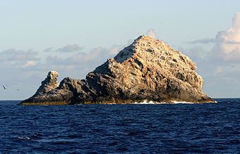
The Gardner Pinnacles (Hawaiian: Pūhāhonu) are two barren rock outcrops surrounded by a reef and located in the Northwestern Hawaiian Islands at 24°59′56″N 167°59′58″W.
Map of Gardner Pinnacles, Hawaii, USA
It is 511 nautical miles (946 km; 588 mi) northwest of Honolulu and 108 miles (94 nmi; 174 km) from French Frigate Shoals. The total area of the two small islets—remnants of an ancient volcano—is 5.939 acres (24,030 m2). The highest peak is 170 feet (52 metres). The surrounding reef has an area in excess of 600,000 acres (2,400 km2; 940 sq mi).
Gardner Pinnacles was first discovered on June 2, 1820, by the American whaler Maro commanded by Captain Joseph Allen.
The Gardner Pinnacles are home to some species of fish not found anywhere else in the Northwestern Hawaiian Islands, and have more species of coral than two rocky neighbors to the south, Necker Island and Nihoa. Numerous insects live on the island, and a researcher claims to have found two new species of spiders here.
Since this is part of a wildlife refuge, Gardner Pinnacles is off limits to even the military, although they made an unauthorized landing in 1961 or 1962 and blew off the tip of the outcrop to create an emergency helicopter landing spot for the Hawaiian HIRAN project, an effort to determine location of area islands with great precision for navigational purposes. To this day the tip has not been replaced, and debris from the blast can be found scattered throughout the island. In the Hawaiian Archipelago, adjacent islands/reefs are French Frigate Shoals to the southeast, and Maro Reef to the northwest.