
Access road | Beach length 1 km | |
 | ||
Location South of Praia in Santiago, Cape Verde Similar Pro‑Cathedral of Our Lady of Grace, Monumento de Diogo Gomes, Farol de D Maria Pia, Museu Etnográfico da Praia, Estádio da Várzea | ||
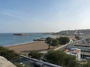
Gamboa or Chã das Areias (or as Cha das Areias) is Praia's second historic part and forms the southernmost part of the city center, it is located in the island of Santiago, Cape Verde. It is also Praia's main beach stretching about 700 meters and is the city's only beach and once popular on the island. The highest point is about 10 meters, the lowest point is the Atlantic and the Praia Harbor. Its length is about 400 meters and 700 meters at the beach/avenue part and its width is about 400 meters from east to west. Its area is about 30 to 40 hectares.
Contents
Map of Gamboa, Cape Verde
Bordering neighbourhoods includes the Platô or the Plateau of Praia to the north, Achada Santo António to the south along with Prainha where much of the embassies are located and Várzea to the west. Four streets borders the neighborhood including Avenida Combatentes da Liberdade da Patria in the east and Avenidas de Cuba and Cidade de Lisboa in the west, it borders the lines next to the new Financial building and Várzea Stadium.
The Ilhéu de Santa Maria separates 30 meters from the island as the highest depth of separation is at only nearly 30 centimeters at low tide, it can be accessible by foot or by boat. That portion is the subdivision boundary.
Earlier buildings with colonial and neoclassical architecture dominates the east, the rest are dominated by the buildings with later architecture built in around the 1940s, some of them have been built after independence in 1975.
It has the National Archives Buildings which is located on the shoreline street. In the north part, it serves the headquarters of Cabo Verde Telecom, the country's only telecommunications line, it has a street named after it. Two piers dominate the middle part of the beach. The Capeverdean Basketball, Volleyball and Athletics Federations are located in the neighborhood of Gimodesportivo Vavá Duarte. Nearby is the Marine Police station which is also used by the Coast Guard.
History
Early in the 16th century, the low-lying areas were forested with kapok trees, they were cut down to make room for farming and agriculture, the forest stretched up to Ribeira Grande. Agriculture dominated the landscape until the 1880s. Later some portions of the forest were restored mainly with palm trees in the 18th century and the remainder restored with kapok trees and dominated north of Gamboa. Later, it intermingled with buildings and landmarks built in the 1940s and the mid 20th century, a dense palm grove as they were in the mid-20th century no longer exists.
In the earlier times, it was called Praia de Santa Maria The first buildings were built in around the 18th century and more later in the 19th century, it contains numerous historic buildings. The area was the Port of Praia and contained two piers, a smaller wooden pier further south. It also had the customs house and the port office there and a mole (in the Plateau area). The southern wooden pier no longer exists today, another would be built north of the main pier, the north pier no longer exists today, only remains exists.. That time, the beach was shorter, as more beach sands filled in the 20th century, land would extend to around 100 meters (300 feet) Thus, the port was completely relocated to Ponto de Visconde (now Ponto de Porto Novo) in around the mid to late 1950s where the landing place is located at the south of Achada Grande Tras next to its edges with Achada Grande Frente. Gamboa became a completely usable beach, the deepest area is about two meters deep. Rua do Porto was made in around the 1960s.
After independence in 1975, the Gimodesportivo Vava Duarte was built and would house the basketball and volleyball teams of Praia. The office of Electra, an electricity company was established in 1982 replacing Central Eléctrica da Praia (CEP - Praia Central Electricity) building. Later the Cape Verdean National Archives was founded on December 31, 1988, under the decree number 128/88, it has about 6,000 lineal meters of books, works, documents, photos and others.
Since 1993, the Praia de Gamboa Music Festival takes place each year in the summer, it is the second largest music festival in Cape Verde after Festival de Baía das Gatas in the northwest on São Vicente Island.
A 10-meter tip existed between 2002 and 2012 which separated the islet only 15 meters; it is now separated by 30 meters.
In 2002, Rua do Porto became Rua de Combatadores de Liberatores da Praia and was widened to four lanes and also extended by a kilometer in the north, the street was finished in 2003 and has two rotaries in the neighborhood.
Landmarks and points of interest
Panoramics
Panoramics includes the south of the island along with the island's tallest summit Pico da Antónia, it has the view of the Praia Plateau to the north, Ilhéu de Santa Maria to the southeast, Achada Grande and the Port of Praia to the east, Achada Santo António to the south and Várzea and its westcentral suburbs to the west, a bit of Monte Vermelho can be seen.
Transportation
Four transit lines passes through the neighborhood often or sometimes, the last three do not cross by the Atlantic, they include: