
Country United States FIPS code 29-26308 Elevation 281 m Population 1,762 (2013) Area code 660 | Time zone Central (CST) (UTC-6) GNIS feature ID 0766157 Zip code 64640 Local time Thursday 5:49 PM | |
 | ||
Weather 11°C, Wind N at 23 km/h, 30% Humidity Area 7.174 km² (7.122 km² Land / 5 ha Water) | ||
Julie v from gallatin missouri shares her 2003 saturn vue buying story
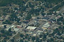
Gallatin is a city in Daviess County, Missouri, United States. The population was 1,786 at the 2010 census. It is the county seat of Daviess County.
Contents
- Julie v from gallatin missouri shares her 2003 saturn vue buying story
- Map of Gallatin MO 64640 USA
- History
- Geography
- 2010 census
- 2000 census
- Education
- Media
- Notable residents
- References
Map of Gallatin, MO 64640, USA
History
Gallatin was founded in 1837 and named for Albert Gallatin, America's longest-serving Secretary of the Treasury (1801–1814). Gallatin was incorporated in 1857.
The Gallatin Election Day Battle took place on 6 August 1838, when about 200 people attempted to forcibly prevent Mormons from voting in the newly created county's first election. The skirmish is often cited as the opening event of the 1838 Mormon War. Gallatin is important in the Mormon religion; nearby is a place known to Mormons as Adam-ondi-Ahman, believed to be the site where Adam and Eve lived after being expelled from the Garden of Eden.
In 1892, Grand River College moved from Edinburg, Missouri to Gallatin, where it operated for a period under the auspices of William Jewell College before permanently closing in 1910 following a fire.
The Daviess County Rotary Jail and Sheriff's Residence, the A. Taylor Ray House and the Daviess County Courthouse are listed on the National Register of Historic Places.
Geography
Gallatin is located at 39°54′43″N 93°57′43″W (39.912073, -93.961930). According to the United States Census Bureau, the city has a total area of 2.77 square miles (7.17 km2), of which, 2.75 square miles (7.12 km2) is land and 0.02 square miles (0.05 km2) is water.
2010 census
As of the census of 2010, there were 1,786 people, 712 households, and 471 families residing in the city. The population density was 649.5 inhabitants per square mile (250.8/km2). There were 880 housing units at an average density of 320.0 per square mile (123.6/km2). The racial makeup of the city was 98.0% White, 0.3% African American, 0.1% Native American, 0.1% Asian, and 1.5% from two or more races. Hispanic or Latino of any race were 0.7% of the population.
There were 712 households of which 33.4% had children under the age of 18 living with them, 49.3% were married couples living together, 12.2% had a female householder with no husband present, 4.6% had a male householder with no wife present, and 33.8% were non-families. 30.3% of all households were made up of individuals and 14% had someone living alone who was 65 years of age or older. The average household size was 2.47 and the average family size was 3.04.
The median age in the city was 38.6 years. 26.6% of residents were under the age of 18; 8.1% were between the ages of 18 and 24; 22.9% were from 25 to 44; 24.1% were from 45 to 64; and 18.3% were 65 years of age or older. The gender makeup of the city was 46.7% male and 53.3% female.
2000 census
As of the census of 2000, there were 1,789 people, 771 households, and 477 families residing in the city. The population density was 640.1 people per square mile (246.7/km²). There were 905 housing units at an average density of 323.8 per square mile (124.8/km²). The racial makeup of the city was 99.27% White, 0.06% African American, 0.22% Native American, 0.06% from other races, and 0.39% from two or more races. Hispanic or Latino of any race were 0.39% of the population.
There were 771 households out of which 31.0% had children under the age of 18 living with them, 49.5% were married couples living together, 9.9% had a female householder with no husband present, and 38.1% were non-families. 35.5% of all households were made up of individuals and 20.2% had someone living alone who was 65 years of age or older. The average household size was 2.25 and the average family size was 2.92.
In the city, the population was spread out with 25.8% under the age of 18, 7.2% from 18 to 24, 24.0% from 25 to 44, 20.7% from 45 to 64, and 22.3% who were 65 years of age or older. The median age was 40 years. For every 100 females there were 83.3 males. For every 100 females age 18 and over, there were 76.5 males.
The median income for a household in the city was $32,321, and the median income for a family was $41,857. Males had a median income of $27,460 versus $27,448 for females. The per capita income for the city was $16,537. About 13.2% of families and 22.2% of the population were below the poverty line, including 30.2% of those under age 18 and 12.4% of those age 65 or over.
Education
PreK-12 public education is provided by the Gallatin R-V School District. PreK-6 is located at Covel D. Searcy Elementary School, and 7-12 at Gallatin High School.
Of adults 25 years of age and older in Gallatin, 85.2% possess a high school diploma or higher, while 12.8% hold a bachelor's degree or higher as their highest educational attainment.
Media
Gallatin is served by a weekly newspaper, the Gallatin North Missourian, which has circulated since 1865.