
Country United States Opening date 1970 Length 860 m | Purpose Flood control Height 50 m Total capacity 188.2 million m³ | |
 | ||
Similar Santa Rosa Dam, Jemez Canyon Dam, Cochiti Dam, Angostura Diversion Dam, Mesilla Diversion Dam | ||
Galisteo Dam (National ID # NM00002) is a dam in Santa Fe County, New Mexico.
Map of Galisteo Dam, Los Cerrillos, NM 87010, USA
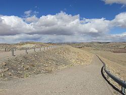
The earthen dam was constructed in 1970 by the United States Army Corps of Engineers with a height of 164 feet and 2820 feet long at its crest. Built solely for flood control and sediment impoundment on Galisteo Creek, with its "long history of violent floods", the main line of the Atchison, Topeka and Santa Fe railroad was relocated to accommodate the project. The dam is owned and operated by the Corps of Engineers.
The reservoir it creates, Galisteo Reservoir, is ordinarily dry. Its maximum capacity is 152,600 acre-feet. No water recreation is available. Although the approximately five-acre site is open to the public for day use, the site is surrounded by private lands and lands of the Kewa Pueblo.