
Area 4.035 km² Established 1970 | Nearest city Waterloo | |
 | ||
Management | ||
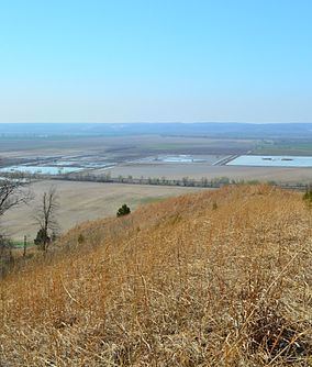
Fults Hill Prairie State Natural Area, also known as the Fults Hill Prairie Nature Preserve, is an Illinois Nature Preserve on 997 acres (403 ha) in Monroe County, Illinois, United States. A key feature of the preserve is a 532-acre (215 ha) hill prairie located on the east bluff of the Mississippi River overlooking the American Bottom near Fults, Illinois. The Fults Hill Prairie has been listed as a National Natural Landmark.
History and description
The upland or hill prairie was once the dominant ecosystem for much of the land that became the U.S. state of Illinois, the Prairie State. The state's Department of Natural Resources, which owns the prairie parcel, describes it as containing "the largest complex of the highest quality, essentially undisturbed loess hill prairies along the Mississippi River in Illinois." Most of the prairie acreage that makes up this parcel apparently remained un-plowed during the pioneer years of the 1800s.
The nature preserve was dedicated as an Illinois Nature Preserve in 1970, and was listed as a National Natural Landmark in 1986.
The preserve is located approximately 1.6 miles (2.6 km) south of Fults. It is owned and managed by the Illinois Department of Natural Resources.