
- elevation 8,819 ft (2,688 m) - elevation 4,250 ft (1,295 m) - max 1,360 cu ft/s (39 m/s) Basin area 1,945 km² Source Johnson Valley Reservoir Country United States of America | - location near Hanksville, Utah - average 83.9 cu ft/s (2 m/s) Length 153 km Basin area 1,945 km² Mouth Dirty Devil River | |
 | ||
- location Johnson Valley Reservoir Similar Capitol Reef National, Boulder Mountain, Thousand Lake Mountain, Cathedral Valley Corral, Henry Mountains | ||
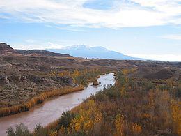
The Fremont River in Utah flows from the Johnson Valley Reservoir, which is located on the Wasatch Plateau near Fish Lake, southeast through Capitol Reef National Park to the Muddy Creek near Hanksville where the two rivers combine to form the Dirty Devil River, a tributary of the Colorado River. The river is 95 miles (153 km) long.
Contents
Map of Fremont river, Utah, USA
CourseEdit
The Johnson Valley Reservoir is fed by Sevenmile Creek (from the north) and Lake Creek (from the southwest). The Fremont River passes through Fremont, Loa, Lyman, Bicknell, Teasdale, and Torrey and provides year round irrigation for the agricultural lands of Rabbit Valley and Caineville. Then it heads through Hanksville and afterwards to its mouth.
MiscellaneousEdit
The Fremont River has a drainage area of 751 square miles (1,950 km2) fed by spring snowmelt off Thousand Lake Mountain, Boulder Mountain, and the northern Henry Mountains. The river is named after John Charles Fremont. It gives its name to the Fremont culture, a Precolumbian archaeological culture.
FlowEdit
Flow (ft^3/s), by month (1977–2003), at Bicknell gauging station: