
Country Netherlands Province North Holland | Time zone CET (UTC+1) Municipality Amsterdam | |
 | ||
Frederik Hendrikbuurt is a neighbourhood in the West district of Amsterdam, Netherlands and is situated between the canals Singelgracht and Kostverlorenvaart. The neighbourhood, known locally by the moniker the "Fred", is centred on the Frederik Hendrikplantsoen park and was planned during the last quarter of the nineteenth century as a confluence of green space and housing meant to be stand apart from the overcrowded Jordaan district. The construction of the neighbourhood was mostly complete by the start of the Second World War (1940).
Map of Frederik Hendrikbuurt, Amsterdam, Netherlands
In the tradition of naming high-status areas after prominent figures, the neighbourhood is named after Frederik Hendrik (1584 - 1647); Prince of Orange, Count of Nassau, governor, captain-general and admiral-general of the Dutch Republic.
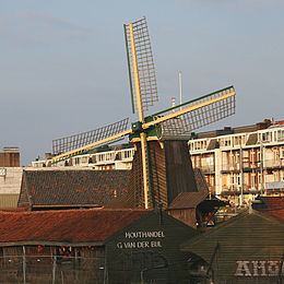
Between the seventeenth century and the end of the nineteenth century the area was the "Sawmill Area". There were many mills for sawing timber, for shipbuilding and housing. The remaining windmill "de Otter" can still be found along the Kostverlorenvaart.