Primary outflows Hollenbach Max. depth 2.60 m (8 ft 6 in) Primary outflow Hollenbach | Surface elevation 623 m Parent range Hoher Meissner | |
 | ||
Primary inflows Similar Hoher Meissner, Kalbe, Kaufungen Forest, Erlebnispark Ziegenhagen, Gewächshaus für tropische | ||
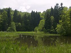
Frau-Holle-Teich is a pond in Hoher Meißner, Werra-Meißner-Kreis, Hesse, Germany. The pond lies at an elevation of ca. 623 m.
Map of Frau-Holle-Teich, 37290 Mei%C3%9Fner, Germany
References
Frau-Holle-Teich Wikipedia(Text) CC BY-SA
