
 | ||
Restaurants Strongwa Food and Spirits, Tommy's Diner, Florentine, Phillips Original Coney Isl, Rehab Tavern Hotels Knights Inn Downtown Columbus, Inn Towne Motel, Travelodge ‑ Columbus, Budget Inn, Columbus hotel | ||
Franklinton is a neighborhood in Columbus, Ohio. Franklinton is the original settlement in Franklin County, Ohio. As the city of Columbus grew, the city annexed and incorporated the existing settlement and today it exists as a neighborhood immediately west of downtown.
Contents
- Map of Franklinton Columbus OH USA
- Settlement and founding 17951859
- Post annexation 18601899
- 20th century 19001999
- 21st century 2000present
- Geography
- Land use
- Housing
- Parks
- Landmarks
- Green Lawn Abbey
- Harley Davidson Motor Co
- Holy Family Catholic Church
- Rail Depot
- Floodwall
- Broad Street
- Sullivant Avenue
- Franklinton Plan
- The McKinley Avenue Corridor Plan
- References
Map of Franklinton, Columbus, OH, USA
A portion of the neighborhood gets its nickname of "The Bottoms" because much of the land lies below the level of the Scioto and Olentangy rivers, and a floodwall is required to contain the rivers and protect the area from floods. The low-lying bottom land was well suited for farming, with the river serving as a direct connection to the Ohio River.
Settlement and founding (1795–1859)
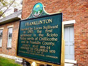
In 1795 Lucas Sullivant was employed by the Commonwealth of Virginia to survey the Central Ohio portion of the Virginia Military District . Sullivant, along with approximately 20 men surveyed the western side of the Scioto River at the confluence of the Olentangy and Scioto Rivers. As payment for his work, Sullivant was given 6000 acres in the Refugee Tract reserved for those who aided the American Revolution. Sullivant, after surveying the land, returned to Kentucky where he courted Sarah Starling, the daughter of his mentor Colonel William Starling. In 1797, Sullivant returned to the Ohio and laid out a village of 220 lots in Franklin County, which he named Franklinton in honor of the recently deceased Benjamin Franklin. This original settlement was abandoned in 1798, a year later, when a flood submerged most of the town. Sullivant relocated the town less than a mile away, off of the banks of the Scioto River.
The replatted town was laid out in blocks that contained four lots in a square, with each lot measuring 99’ wide by 115’ deep. To encourage people to move to the new settlement, Sullivant offered free land for anyone willing to build a house along Gift Street, near the eastern edge of his plat. Along with platting and settling the town, Sullivant also built several structures out of brick and glass from Philadelphia. These buildings included a courthouse, a brick home to impress Starling (who was wed to Sullivant in 1801), a brick church and the first bridge across the Scioto River.
The town of Franklinton was then made the County Seat of Franklin County in 1803, when Franklin County was created from Ross County. The population and town grew during the War of 1812, as Franklinton served as a staging point for General William Henry Harrison’s army. Following the war, the community continued to grow with the expansion of the country's railway system along with the construction of a new state capitol, Columbus, on the east, or opposite, side of the Scioto River. Columbus’s growth eventually led to the relocation of the county seat to the City of Columbus in 1824 and the annexation of Franklinton by the City of Columbus in 1859.
In 1846, traveler Henry Howe had this to say about Franklinton: "Franklinton lies on the west side of the Scioto, opposite Columbus. It was the first town laid off in the Scioto valley N. of Chillicothe. From the formation of the county, in 1803, it remained its seat of justice until 1824, when it was removed to Columbus. During the late war, it was a place of general rendezvous for the N.W. army, and sometimes from one to three thousand troops were stationed there. In those days, it was a place of considerable note: it is now a small village, containing, by the census of 1840, 394 inhabitants."
He visited again in 1886, writing: "Franklinton now is included in the city of Columbus. It has changed less than any part of the city so near the centre, and preserves to this day many of its old style village features. It is a quiet spot, but cannot much longer so remain in the rapid progress of improvements."
Post-annexation (1860–1899)
During the last half of the nineteenth century, four railroads were established in Franklinton and brought commercial and industrial growth. In 1850, the Columbus and Xenia Railroad Company was chartered to build and operate a railroad that ran from Columbus, Ohio to Xenia, Ohio. This railroad was the first to run through Columbus and into central Franklinton. The growth of local railroads and governmental action in the United States, including Abraham Lincoln’s Pacific Railway Act, caused railroads to become a major form of transportation in the twentieth century. By 1902, the popularity of the railroads forced Ohio canals into retirement. The need for interurban travel created Columbus interurban railways.
Franklinton quickly transformed from a farming based community to an urban society known for its railroad cars and horse-drawn buggies. The railroad service and industrial development drew people from the southwest part of the state and West Virginia. Many of these people chose to reside in the East Franklinton area to be closer to the industrial activity. Although Franklinton continued to grow as an industrial center, the frequent flooding near most of the industrial development proved to be problematic. Franklinton experienced multiple minor floods, which ravaged the west side in 1834, 1847, 1852, 1859, 1860, 1862, 1866 (the river rose 12 feet that year),1868,1869,1870,1881, and 1883.
In 1889, the city spent $50,000 to construct massive levees along the banks of the Scioto. The majority of the current houses in Franklinton were built after the completion of these levees.
On September 14, 1897, Columbus held a three day Centennial celebration for Franklinton. Local and notable guests were invited to speak at the celebration. Though the speeches praised Lucas Sullivant's courage and hard work, many agreed that, in retrospect, the flood-prone area had been unfit for settlement. Also, the original neighborhood design had not included alleys.
20th century (1900–1999)
The town Franklinton experienced extreme flooding when the wooden levees, holding the Scioto River, collapsed on March 25, 1913. The Great Flood of 1913 engulfed the neighborhood of Franklinton with 7 to 17 feet of water. Police officers in horse-drawn carriages traveled the flooded streets, warning residents to head to the higher ground of the adjacent Hilltop neighborhood. While recording the devastation of the flooding, Robert F. Wolfe, publisher of the Columbus Evening Dispatch, chartered an interurban train from Columbus to Buckeye Lake and took nine motorboats and 20 rowboats with him to the rivers edge. From Rich & Scioto Street he was able to help residents who could not get to higher ground. The rising of the waters swept ninety-three people to their deaths and left 20,000 people homeless. It also destroyed nearly 500 buildings and every bridge in the downtown area. A large number of residents relocated to the Hilltop. As a result, property values dropped as much as 50%. Early estimates of the flood damage to homes and businesses came in at five million dollars with the eventual total climbing to $22 million. The damages from The Great Flood of 1913 led to some the first watershed planning and flood-control measures.
The 1959 Flood was the last major flood to hit the Franklinton area. On January 22, 1959, the Frank Road crest on the Scioto River came and was 27.22 ft. above the flood stage level. The frozen ground throughout the area was partly responsible for the large volume and rapid rate of runoff of the heavy rain.
In 1983, The Federal Emergency Management Agency declared almost all of Franklinton to be a floodplain. The City Council adopted an ordinance that restricted building in the area. The federal guidelines that prohibited all types of construction caused Franklinton to face a gradual population decline.
During the latter half of the twentieth century, the construction of the Interstate Highway system had a major effect on Franklinton. The inner belt construction of the 1960s removed several buildings along Sandusky Street, resulting in lowered property values and driving families out of East Franklinton. In addition to the land use and population changes that occurred, the inner belt formed a barrier which sealed off the side of East Franklinton that was not bordered by the Scioto River. This isolation was reinforced with the construction of West Interstate 70.
21st century (2000–present)
Today, Franklinton is an urban neighborhood consisting of about 36,000 residents. Though recent redevelopment efforts have improved the area, 56% of Franklinton residents lack a high school diploma, over 60% of residents live below the poverty line, and 93% of students at the school’s public elementary school are eligible for free or reduced lunch.
The Franklinton Floodwall, completed in 2004, is 7 miles long, cost $134 million, and is able to protect the area to crests of up to 30.9 ft. The wall's completion has released the area from being considered a floodplain, as well as releasing the previous building restrictions that often prevented development in the past. As a result, commercial and industrial activities are starting to grow in the East Franklinton Area. This resurgence is evidenced through multiple community plans, as well as the creation of the Franklinton Area Commission.
Between 2009 and 2011, the Columbus Metropolitan Housing Authority demolished three housing projects in the East Franklinton area. Two high rises, Sunshine Annex and Sunshine Terrace, and a 127 unit apartment complex, Riverside Bradley. The population in East Franklinton was greatly reduced as a result.
During this time, the city of Columbus rehabbed 16 homes through a program called Home Again.
Also during this time, Franklinton benefited from the Housing and Economic Recovery Act of 2008 (signed into law by George W. Bush) and its follow up, the American Recovery and Reinvestment Act of 2009 (signed into law by Barack Obama). The funds from these acts passed through the Neighborhood Stabilization Program, and led to the building, rehabilitation, or demolition of over 100 houses in Franklinton, through organizations like Habitat for Humanity and the Franklinton Development Association.
The City of Columbus is focusing on creating a new Short North style neighborhood in Franklinton through developing an urban creative district. This new neighborhood is now centered between Gift, Town, Lucas, and Rich Streets, with hope to expand to East Franklinton. The first main developers in the area are Goody Clancy, Urban Smart Growth, Franklinton Development Association, Lance Robin, and Chris Sherman. These key developers have purchased existing buildings and are working to refurbish existing buildings to retain the character of Franklinton.
Geography
Franklinton is a neighborhood bordered by the Scioto River on the north and east, Harmon Avenue on the east, Stimmel Road and Greenlawn Avenue on the south, and Interstate 70 on the west. West Broad Street, also known as U.S. Route 40 or the National Road, is Franklinton's main thoroughfare. It is the neighborhood immediately west of Downtown Columbus, Ohio. A floodwall is required to contain the rivers and protect the area from devastating floods. Just west of Franklinton is a large group of smaller neighborhoods commonly referred to as "The Hilltop".
Land use
Franklinton is characterized by a mix of land uses, reflecting its pattern of development as an independent, self-sufficient community. Some sub-districts can contain a mix of residential, commercial, office, research, institutional or certain light industrial uses, even within the same building. Arts-related uses are emphasized while existing single-family homes are protected.
Three sub-districts have been established in which land uses are organized: Broad Street, Arts and Innovation, and Dodge Park. These are consistent with the way the East Franklinton Plan was organized. The Broad Street and Arts and Innovation sub-districts strongly support mixed uses and the Dodge Park sub-district (north of Dodge Park) emphasizes residential. Single and multi-family residential use plots are located throughout the area. Most commercial uses are concentrated along West Broad Street. These include both neighborhood-oriented and regional commercial uses, including large office complexes and a retail center. In addition, there are many manufacturing land uses in Franklinton, with the heaviest concentrations along McKinley and Harmon avenues. Franklinton also contains several institutional and public land uses. The Center of Science and Industry (COSI), Mt. Carmel West Medical Center, and Veterans Memorial are among the major land users within this category.
Housing
As of the 2000 US Census, there are 5,444 housing units in Franklinton. About 1,000 of these units, roughly 18.4%, are unoccupied. Only 29.2% of housing units in Franklinton are occupied by their owners. The proportion of rental homes in Franklinton is higher than the average rates in most Columbus neighborhoods. The Columbus Metropolitan Housing Authority is an organization which aims to help people who have difficulty in affording housing, as well as build healthy living environments for the community. The CMHA formed at 1934, and begin its construction of public housing in 1937. The first project was the Poindexter Village, named for James Preston Poindexter, which can accommodate more than 400 families.
Parks
The Franklinton neighborhood contains several parks, such as McKinley Park, Cody Park, Maurice Gates Memorial Park, and Genoa Park. McKinley Park is a neighborhood park located at McKinley Ave. in northwest Franklinton. The neighborhood consists of 6.95 acres, which includes athletic fields, basketball courts, picnicking facilities, and playgrounds. The area serves as a public space for the residents. Cody Park, located on Brehl Avenue, covers 0.29 acres of land and has a playground similar to Maurice Gates Memorial Park. Genoa Park, previously named the Riverfront Amphitheater, can be found on the west bank of the Scioto River. It has an area of 2.07 acres and access to a greenway walking trail for residents to enjoy. Genoa Park hosts events such as Rhythm on the River, Waterfire, and the Latino Festival.
Landmarks
The Dodge Recreation Center, Sullivant Gardens Community Center, McDowell Senior Center are three recreational centers located in the Franklinton neighborhood. The Dodge Recreation Center and Sullivant Avenue provides various facilities such as athletic fields and swimming pools for the community. Franklinton contains several centers for restaurants and social spaces. In terms of social spaces, Franklinton is positioning itself to become a new creative district of Columbus.
Green Lawn Abbey
In 1927, the Green Lawn Abbey was built by the Columbus Mausoleum Company. The private community mausoleum was designed with a gray granite exterior and columned second-floor portico. In the nineteenth century, cities were closing burying grounds within city limits. Private community mausoleum began to appear in the 1920s. Green Lawn Abbey was the largest with 654 crypts, one-and-a-half-thick walls, marble floors, a central chapel and foyer area and stained-glass windows.
Harley-Davidson Motor Co.
The family-owned company A.D Farrow settled in Franklinton in 1941 and is the oldest Harely-Davidson dealership in America. In 1983, Alan and Pat Doerman purchased the dealership and refurbished the original building. The original shop has since been refashioned as the A.D Farrow Museum. In 2002, the dealership celebrated the 100th anniversary of Harley-Davidson.
Holy Family Catholic Church
The Gothic-style church began construction in 1885. It was completed on June 2, 1889 and dedicated by Bishop Watterson. The Gothic-style church can seat one thousand. During the Flood of 1913, upper floors were used to provide flood relief.
Rail Depot
The Depot moved to the Old Henderson Road in 2003. It was located in Brice, Ohio during the 1880s. It has been kept in its original form and has been used to hold different kinds of events. The ceiling is still in its original red pine bead board, with hand-hewn hickory floors. Inside the Depot are walls from a Quaker church that are 150 years old and tables made out of 300-year-old hardwoods. Every detail in the Depot has been preserved in its original appearance.
Floodwall
The Franklinton Floodwall began construction in 1993 and was completed in 2004 at an expenditure of 193 million dollars. The wall protects the area from flooding by the Scioto River. A flood in 1959 was one of the worst disasters in Franklinton’s history.
Broad Street
Broad Street is one of the major east-west main stems in Franklinton. It is situated between McKinley Avenue and Town Street. Broad Street intersects Central Avenue, Glenwood Avenue, and High Street in addition to running beneath both SR 315 and I-71 making it one of the most significant roads in Columbus. In the Columbus Thoroughfare Plan, it was classified as a type “6-2” arterial, meaning six moving lanes, flowing two ways. As the name implies, Broad Street is a wide street with about a 60-foot width, and carries around 16,000 vehicles a day.
Sullivant Avenue
The Sullivant Avenue is another major east-west main stem in Franklinton. Unlike Broad Street, it is a “4-2D” type arterial, in other words it is “four moving lanes, two way and a median divider on mainline sections”. Sullivant Avenue goes past I-70, Central Avenue, Glenwood Avenue, and ends at Gift Street to the east. It lies between Town and Mound Streets.
Franklinton Plan
The Franklinton Plan was compiled by the City Council in 2003 as a plan for the future of the Franklinton Area. It showed the current condition, goals, policies, and strategies for different planning aspects. The plan contains sections covering improvements in land use and zoning, housing, parks recreation and open space, traffic and streets, sanitary sewers, urban design, historic preservation, and economic development.
The McKinley Avenue Corridor Plan
The McKinley Avenue Corridor Plan was initiated in 2000. This plan concerns an area 1.5 miles west of downtown, accessible from I-270, I-70, Broad Street and State Road 33. The McKinley Avenue Corridor is one of the most productive employment areas in Columbus with more than 5,000 employees. This plan mainly focused on the property, land use and zoning, streets and traffics, as well as public safety problems.
According to the Franklinton Area Commission: