
Elevation 869 m Prominence 110 m Added to NRHP 23 November 1977 | Area 85 ha | |
 | ||
Similar Grassy Mountain, Brasstown Bald, Blood Mountain, Springer Mountain, Arabia Mountain | ||
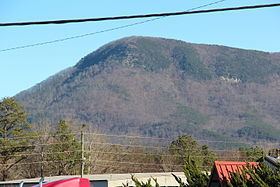
Fort Mountain is a mountain in northern Georgia, just east of Chatsworth. It is part of the Cohutta Mountains, a small mountain range at the southern end of the Appalachian Mountains. It also lies within the Chattahoochee National Forest.
Map of Fort Mountain, Georgia 30705, USA
Fort Mountain takes its name from a peak that has remnants of a stone formation around part of that peak. The stones, which are from the local area around the summit, are piled in an 928 feet (283 m)-long discontinuous zig-zag line. Stone piles may be formed naturally by the thrust that causes a ridge to crest during the mountain's formation.
Early visitors referred to the formation as a fort, speculating that it was built by Hernando de Soto to defend against the Creek Indians around 1540. However, this theory was contradicted as early as 1917, as a historian pointed out that de Soto was in the area for less than two weeks.
The original construction and function of the formation as a fort is less accepted today and its origin remains unknown. The formation has been attributed to pre-Columbian native Americans. Early historians attributed the stone piles to a race of moon-eyed people, said to predate the Cherokee. The earliest known mention of this was by Benjamin Smith Barton (1766-1815).
Around and mostly south of the fort peak is Fort Mountain State Park, with camping and hiking areas, a mountain lake, and a variety of public facilities.