
Country United States Ward Ward 5 | District Washington, D.C. Area 122 ha | |
 | ||
Fort Lincoln is a neighborhood located in northeastern Washington, D.C. It is bounded by Bladensburg Road to the northwest, Eastern Avenue to the northeast, New York Avenue NE to the south, and South Dakota Avenue NE to the southwest. The town of Colmar Manor, Maryland, is across Eastern Avenue from the Fort Lincoln neighborhood, as is the Fort Lincoln Cemetery.
Contents
- Map of Fort Lincoln Washington DC USA
- Neighborhood
- Civil war site and cemetery
- Fort Lincoln Park
- References
Map of Fort Lincoln, Washington, DC, USA
The name Fort Lincoln was originally used for a Civil War Fort in adjacent Prince George's County, Maryland, across the D.C. line from the Washington neighborhood bearing its name.
Neighborhood
This northeast Washington neighborhood is home to the Fort Lincoln "New Town" development constructed in the 1960s and 1970s. This neighborhood is currently the home of Cathy Lanier, Chief of the D.C. Metropolitan Police. In 2011 another 42 acres of the wetland forest park was sold to make a shopping center.
Civil war site and cemetery
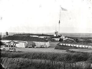
The Fort Lincoln area includes a Civil War-era fort, Fort Lincoln, constructed in 1861 for the defense of Washington. The fort is now part of Fort Lincoln Cemetery, and can be visited.
Fort Lincoln Park
Fort Lincoln is a Civil War earthwork in the Fort Lincoln neighborhood. It was constructed in 1861 for the defense of Washington. The fort was built along the District line in adjacent Prince George's County, Maryland, directly along the line of the Baltimore and Ohio Railroad between Baltimore, Maryland, and Washington.
The fort had a perimeter of 466 yards (426 m), and places for 34 guns, including one 100-pound Parrott rifle.
The fort is within Fort Lincoln Cemetery, and can be visited.