
Basin size 1,775 km (685 sq mi) Mouth Tyrrhenian Sea Country Italy | Length 127 km Province Province of Cagliari Mouth elevation 0 | |
 | ||
Main source Monte Armidda (Gennargentu massif)
1,270 m (4,170 ft) River mouth Tyrrhenian Sea near Muravera and Villaputzu
0 m (0 ft) | ||
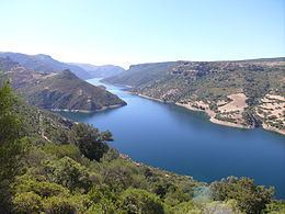
The Flumendosa is a river of southern Sardinia, Italy. With a length of 127 kilometres (79 mi), it is the second longest river of the island behind the Tirso.
Map of Fiume Flumendosa, Province of Cagliari, Italy
The Flumendosa's springs are located in the Gennargentu massif, at the foot of the Monte Armidda; it flows into the Tyrrhenian Sea near the towns of Muravera and Villaputzu. It drains a basin of about 1,775 square kilometres (685 sq mi). Before the construction of two large dams, it had a discharge of 22 cubic metres per second (780 cu ft/s).
References
Flumendosa Wikipedia(Text) CC BY-SA