SR 10 was defined by number in 1923 state law, chapter 9311, approved June 8, 1923:
Extending from the Georgia State line near Beechton to East Point, via Tallahassee, Crawfordville, Blockers Ferry and Carrabelle.
SR 10 was extended by number in 1925 state law, chapter 10269, approved June 1, 1925:
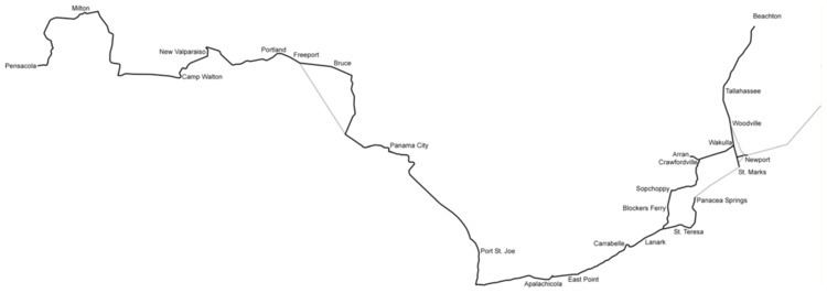
Extending from the Georgia State line near Beachton to Pensacola, via Tallahassee, Woodville, New Port, and as near St. Marks as practicable, and thence around the coast to Panacea Springs, St. Teresa, Lanark, also via Wakulla, Crawfordville, Sopchoppy, Carrabelle, Apalachicola, Port St. Joe, Panama City, near mouth of Choctawhatchie River, Freeport, Portland, New Valparaiso, Camp Walton, and thence into State Road No. 1 at or near Milton and thence over State Road No. 1 connecting with Pensacola.
SR 10 was slightly realigned by number in 1927 state law, chapter 12300, approved May 13, 1927:
Extending from the Georgia State line near Beachton to Pensacola, via Tallahassee, Woodville, New Port, and as near St. Marks as practicable, and thence around the coast to Panacea Springs, St. Teresa, Lanark, also via Wakulla, Crawfordville, Sopchoppy, Carrabelle, Apalachicola, Port St. Joe, Panama City, Bruce, Freeport, Portland, New Valparaiso, Camp Walton, and thence into State Road No. 1 at or near Milton and thence over State Road No. 1 connecting with Pensacola.
A shortcut was added to SR 10 by number in 1929 state law, chapter 13835, approved June 10, 1929:
That certain road extending Four and One-half Miles more or less from Wakulla Station in Wakulla County, Florida, to St. Marks, Florida.
A spur was added to SR 10 by number in 1931 state law, chapter 14991:
From a point on Road 10 between Wakulla and St. Marks as defined in the Acts of 1929, Chapter 13855, as nearly due west of New Port as practicable, to a connection with State Road 19 in Jefferson county, via, New Port, Florida.
The same act repealed part of SR 10:
That part of Road 10 from Woodville via New Port as near as practicable to St. Marks as defined in the Acts of 1925, Chapter 10269.
1931 state law, chapter 15652, approved June 26, 1931, did exactly the same thing as chapter 14991.
Another spur was added by number in 1931 state law, chapter 15645, approved June 26, 1931:
That certain road extending two and one-half miles, more or less, from a point on State Road No. 10 in Wakulla County, Florida, at or near Crawfordville, Florida, at Arran, Florida.
Certain streets in Panama City were defined as part of SR 10 in 1941 state law, chapter 20292, filed May 12, 1941:
Beginning at a point on State Road No. 10 where said road intersects and crosses the Eastern boundary line of the Northwest quarter of Section 11, in Township 4 South, Range 14 West, which is Panama City corporate limits on the East, and running thence Northwesterly and Westerly along State Road No. 10 as constructed by the State Road Department to the Street known as Cherry Street in Milville; thence continuing Westerly along the concrete paved street constructed by Panama City and known as Panama City and Millville Road to Oak Avenue in plat of Old Orchard; thence continuing Westerly and Northwesterly along the concrete paved street and bridge as constructed by the State Road Department across Watson Bayou, thence along the asphalt slag paved street as constructed by the State Road Department to Magnolia Avenue; thence Westerly along the concrete paved streets constructed by City of Panama City as follows: Along Sixth Street to Seaview Avenue or Beach Drive; thence along Seaview Avenue to Frankford Street; thence along Frankford Street to Buna Vista Avenue; thence along Buna Vista Avenue to Chestnut Street; thence along Chestnut Street to Commerce Avenue; thence along Commerce Avenue to Beck Street; thence along Beck Street to Wyoming Avenue; thence Westerly along the asphalt slag street as constructed by State Road Department to the Hathaway Bridge across St. Andrews Bay.
The sections between St. Marks and Panacea and northeast from Newport were never built, though the former was still planned in 1945. Here's what each section became in the 1945 renumbering:
SR 61 from Georgia to south of Tallahassee
SR 363 from south of Tallahassee to north of St. Marks
SR 30 from north of St. Marks to east of Carrabelle
SR 30A from east of Carrabelle to Carrabelle
SR 30 from Carrabelle to west of Panama City
SR 79 from west of Panama City to Ebro
SR 20 from Ebro to Valparaiso
SR 85 in Valparaiso
SR 397 from Valparaiso to Eglin Air Force Base
unnumbered through Eglin Air Force Base
SR 85 from south of Eglin Air Force Base to Fort Walton Beach
SR 30 from Fort Walton Beach to Navarre
SR 87 from Navarre to Milton
SR 10 from Milton to Riverview
SR 10A from Riverview to Pensacola
SR 365 from Wakulla to Shadeville
SR 61 from Shadeville to Medart
SR 375 from Medart to Sopchoppy
SR 377 from Sopchoppy to west of St. Teresa Beach
SR 30 from west of Newport to Newport
unnumbered northeast from Newport
SR 368 from Crawfordville to Arran