
Location South China Sea Municipality Kalayaan, Palawan | Archipelago Spratly Islands | |
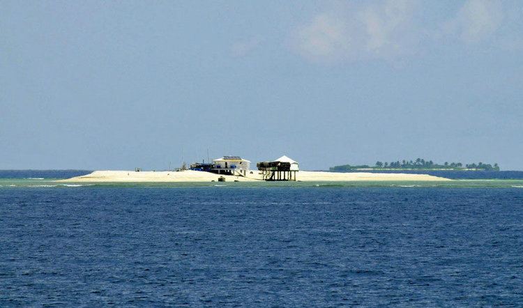 | ||
Flat Island (Chinese: 费信岛; pinyin: Feixin Dao; Tagalog: Patag Island; Vietnamese: Đảo Bình Nguyên) is the second smallest of the Spratly Islands. It has an area of 0.57 hectares (1.4 acres) (5,700 sq. m), and is about 10 kilometres (6.2 mi) north of Philippine-occupied Nanshan Island.
Contents
Map of Flat Island
It is the sixth largest of the Philippine-occupied Spratly islands, and is administered by the Philippines as part of Kalayaan, Palawan. The island is also claimed by the People's Republic of China, the Republic of China (Taiwan), and Vietnam.
Environment
The island is a low, flat, sandy cay, 240m by 90m, and is subject to erosion. It changes its shape seasonally. The sand build up depends largely on the direction of prevailing winds and waves; it has taken an elongated shape for some years, the shape of a crescent moon for a few years, and the shape of a letter "S". Like Lankiam Cay, it is also barren of any vegetation. No underground water source has been found in the area.
Philippine Occupation
Presently, the island serves as a military observation post, and is guarded by Philippine soldiers stationed at nearby Nanshan Island. The soldiers regularly visit the island, and it is kept under observation from a tall structure on Nanshan Island.
In August 2011, the Philippine Navy Seabees (Naval Combat Engineering Brigade) finished construction of a second star shell-like structure which is intended to shelter and protect troops.