
Isolation 150 kilometres (93 mi) First ascent 25 June 2014 Elevation 4,150 m Listing Ultra-prominent peak | Easiest route YDS class 3 | |
 | ||
Prominence 3,709 m (12,169 ft) Ranked 41st | ||
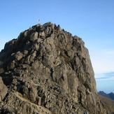
Finisterre Range is a mountain range in north-eastern Papua New Guinea, at 5.8°S 146.1°E / -5.8; 146.1. The highest point 5°57′15″S 146°22′30″E, which is ranked 41st in the world by prominence, has an elevation of 4,150 m. Although the range's highpoint is not named on official maps, the name "Mount Boising" is used locally. This peak was possibly the most prominent unclimbed peak in the world until the first known ascent on 25 June 2014.
Map of Finisterre Range, Papua New Guinea
The range runs into the Saruwaged Range to the east and together they form a natural barrier between the Ramu and Markham valleys to the south and Vitiaz Strait to the north. Many rivers originate in this range, including some tributaries of the Ramu.
The Finisterre Range campaign (1943–1944) of World War II, including a series of actions known as Battle of Shaggy Ridge, saw fierce fighting between Australian and Japanese forces.