
Country United States FIPS code 48-25644 Area 130 ha Zip code 78940 Local time Thursday 9:35 PM | Time zone Central (CST) (UTC-6) GNIS feature ID 1357269 Elevation 120 m Population 262 (2013) Area code 979 | |
 | ||
Weather 21°C, Wind S at 13 km/h, 96% Humidity | ||
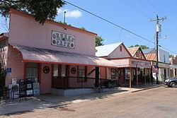
Fayetteville is a city in Fayette County, Texas, roughly halfway between Austin and Houston. The population was 258 at the 2010 census.
Contents
Map of Fayetteville, TX 78940, USA
History
Fayetteville's first immigrant settlers were the families headed by John Crier, James Cummins, and James J. Ross, three of the Old Three Hundred. The settlement began at the location of a stagecoach stop on an old road between San Felipe and Bastrop.
Even though Fayette County was named after General Lafayette, the Revolutionary War hero, the community was named in 1844 after Fayetteville, North Carolina, for a prominent citizen of the time, who had surveyed the community, named its streets, and donated lots for the Fayetteville Academy and the town's multidenominational Union Church.
Fayetteville was incorporated in 1882.
The town made national news during World War I. As reprinted by Stars and Stripes in its March 15, 1918 issue, the town's mayor, W. C. Langlotz, and ten of the town's citizens were charged with espionage. They were arrested following the display of the flag of the German Empire over the entryway of the Germania club in Fayetteville. The group pleaded "not guilty": the mayor said the flag had been displayed by mistake.
Geography
Fayetteville is located in eastern Fayette County at 29°54′18″N 96°40′30″W (29.904922, -96.675119). Texas State Highway 159 passes through the center of town, leading northeast 12 miles (19 km) to Industry and northwest, then southwest a total of 16 miles (26 km) to La Grange, the county seat. Houston is 85 miles (137 km) to the east via secondary highways and Interstate 10, while Austin is 80 miles (130 km) to the northwest via highways 159 and 71.
According to the United States Census Bureau, the city has a total area of 0.50 square miles (1.3 km2), none of which is covered with water. Lake Fayette, a reservoir constructed for power generation, is 4 miles (6 km) west of town.
Demographics
As of the census of 2000, there were 261 people, 120 households, and 71 families residing in the city. The population density was 602.4 people per square mile (234.4/km2). There were 183 housing units at an average density of 422.4/sq mi (164.3/km2). The racial makeup of the city was 96.55% White, 3.07% African American, and 0.38% Asian. Hispanic or Latino of any race were 1.53% of the population.
There were 120 households out of which 20.8% had children under the age of 18 living with them, 48.3% were married couples living together, 10.8% had a female householder with no husband present, and 40.8% were non-families. 35.8% of all households were made up of individuals and 24.2% had someone living alone who was 65 years of age or older. The average household size was 2.17 and the average family size was 2.89.
In the city, the population was spread out with 19.5% under the age of 18, 7.7% from 18 to 24, 20.7% from 25 to 44, 24.5% from 45 to 64, and 27.6% who were 65 years of age or older. The median age was 46 years. For every 100 females there were 74.0 males. For every 100 females age 18 and over, there were 72.1 males.
The median income for a household in the city was $27,639, and the median income for a family was $31,667. Males had a median income of $26,250 versus $18,125 for females. The per capita income for the city was $13,916. About 8.0% of families and 13.2% of the population were below the poverty line, including 37.5% of those under the age of eighteen and 12.7% of those sixty five or over.
Education
The city is served by the Fayetteville Independent School District.