
Population 118 (2011) Civil parish Farnham Local time Thursday 6:15 PM | OS grid reference TM3660 Sovereign state United Kingdom | |
 | ||
Weather 10°C, Wind N at 13 km/h, 62% Humidity | ||
Farnham is a village and civil parish about 3 miles (4.8 km) south-west of Saxmundham in the English county of Suffolk on the A12 road. Its history goes back to at least 1707, Farnham is located West of Friday Street, South of Benhall Street and North East of Straford St Andrew.
Contents
Map of Farnham, UK
According to the 2011 Census there were 57 males and 61 females living in the parish.
Farnham was described, in 1870-72, by John Marius Wilson's Imperial Gazetteer of England And Wales as:
FARNHAM, a parish in Plomesgate district, Suffolk; near the river Alde and the East Suffolk railway. It has a post office under Wickham Market. The living is a vicarage in the diocese of Norwich. The church is Norman, with a flint tower, and very good.
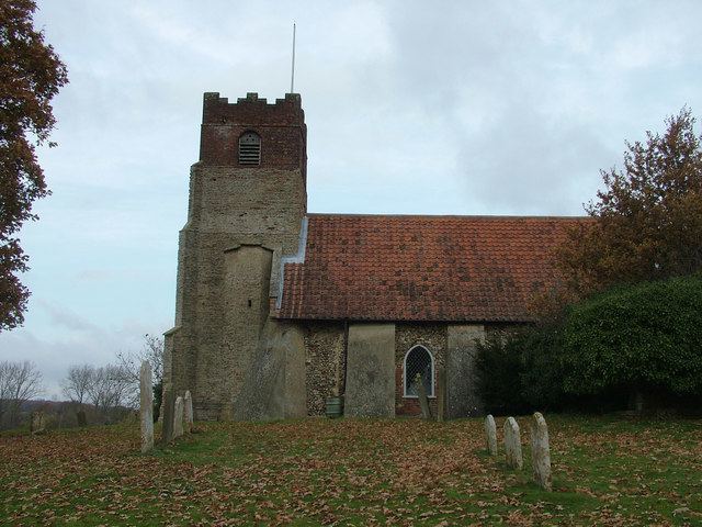
St. Mary's Church
St. Mary's Church is located just South of the village of Farnham and has a long history dating back to the Norman times.
It is thought that the original church building was built around AD800 but was kept hidden due to the nearby environment at the time. It was not recorded in the Domesday Book.
The building that is currently there is built of mostly flint and stone and was built in the Norman time, with most of the interior being the original interior. There are some more recent installments such as the organ which was installed in 2000.
More recently in 1992, after the redundancy of St Andrew's church in Stratford St Andrew, both Farnham and Stratford St Andrew's churches united with both parishes now using St. Mary's Church. St Andrew's Church has been converted into a house.