
- elevation 3,782 ft (1,153 m) - elevation 561 ft (171 m) | - location near Jasper | |
 | ||
- location near Sardine Butte, Willamette National Forest Bridges Pengra Bridge, Unity Bridge | ||
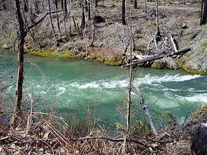
Fall Creek is a 34-mile (55 km) tributary of the Middle Fork Willamette River in Lane County in the U.S. state of Oregon. Beginning in the Cascade Range, the creek flows generally west through the Willamette National Forest to enter the Middle Fork upstream of Jasper, southeast of Springfield and Eugene.
Contents
Along its upper and middle reaches, the creek flows by many campgrounds, picnic sites, a state park, and the Fall Creek National National Recreation Trail. Below Fall Creek Lake, impounded by Fall Creek Dam, the small communities of Unity and Fall Creek lie along the lower reaches. Two covered bridges carry rural roads over the creek, one at Unity and the other further downstream.
Tributaries
Named tributaries of Fall Creek from source to mouth are Buzzard, Briem, Saturn, Delp, and Ninemile creeks. Then come Gold, Pacific, Tiller, Marine, Hehe, Small, and Gibraltar creeks. Further downstream are Alder, Puma, Jones, Portland, and Andy creeks.
Then come Bedrock, Slick, Timber, Boundary, and Little Gold Creek. North Fork Fall Creek is next, after which Winberry Creek enters at Fall Creek Lake. Little Fall Creek enters the main stem in the lower reaches below the lake.
Covered bridges
Unity Bridge at Unity carries Unity–Lowell Road over Fall Creek. The bridge is about 1 mile (1.6 km) below Fall Creek Lake and about 6 miles (10 km) by water from the mouth of the creek. Unity Bridge was added to the National Register of Historic Places in 1979.
Further downstream, Pengra Bridge carries Place Road over the creek along its lower reaches. The 120-foot (37 m) Howe truss structure, built in 1938, was also added to the National Register of Historic Places in 1979.
Hiking and camping
Fall Creek National Recreation Trail runs 13.7 miles (22.0 km) along the creek between the Dolly Varden Campground and a trailhead near Tiller Creek. Access to the generally level hiking trail is via five trailheads at different points along the route. Log footbridges span the side streams of the trail, which connects to other trails, among them Clark Butte, Cowhorn Mountain, Gold Point, and Jones.
Campgrounds are found at intervals along the Fall Creek National Recreation Trail and Forest Road 18. These include Dolly Varden, Big Pool, Broken Bowl, Bedrock, and Puma. Clark Creek Organization Camp, built by the Civilian Conservation Corps in the 1930s, has sites for group camping.
State park
Fall Creek State Recreation Site, a state park at Fall Creek Lake, has a variety of campgrounds and day-use areas, each with amenities that vary from site to site. These include boat launches, swimming areas, picnic areas, toilets, and parking. The 167-acre (68 ha) park is open from May through September.
Fishing
Fishing in Oregon describes the creek as "beautiful" as well as popular with anglers in pursuit of finclipped Chinook salmon, stocked rainbow trout, and wild cutthroat trout. Above Fall Creek Lake, the creek is heavily stocked with rainbow trout as far upstream as Gold Creek. Salmon, steelhead (sea-going rainbow trout), and salmon also frequent the creek downstream of the dam impounding the lake. The lake itself supports populations of largemouth bass, crappie, bluegills, and a few trout.