
Sovereign state United Kingdom Dialling code 01480 | Local time Saturday 4:07 AM | |
 | ||
Weather 10°C, Wind S at 11 km/h, 90% Humidity | ||
Eynesbury is a settlement in Cambridgeshire, England. The population of the settlement is included in the civil parish of Little Paxton. Eynesbury forms part of present-day St Neots, but before 1876 was a separate village. It is situated within Huntingdonshire which is a non-metropolitan district of Cambridgeshire as well as being a historic county of England.
Contents
- Map of Eynesbury Saint Neots UK
- History
- Government
- Religious sites
- Notable people
- Sport and leisure
- Education
- References
Map of Eynesbury, Saint Neots, UK
History
In 1085 William the Conqueror ordered that a survey should be carried out across his kingdom to discover who owned which parts and what it was worth. The survey took place in 1086 and the results were recorded in what, since the 12th century, has become known as the Domesday Book. Starting with the king himself, for each landholder within a county there is a list of their estates or manors; and, for each manor, there is a summary of the resources of the manor, the amount of annual rent that was collected by the lord of the manor both in 1066 and in 1086, together with the taxable value.
Eynesbury was listed in the Domesday Book in the Hundred of Toseland in Huntingdonshire; the name of the settlement was written as Einuluesberiam and Einuluesberie in the Domesday Book. In 1086 there were two manors at Eynesbury; the annual rent paid to the lords of the manors in 1066 had been £44 and the rent had increased to £47.1 in 1086.
The Domesday Book does not explicitly detail the population of a place but it records that there was 76 households at Eynesbury. There is no consensus about the average size of a household at that time; estimates range from 3.5 to 5.0 people per household. Using these figures then an estimate of the population of Eynesbury in 1086 is that it was within the range of 266 and 380 people.
The Domesday Book uses a number of units of measure for areas of land that are now unfamiliar terms, such as hides and ploughlands. In different parts of the country, these were terms for the area of land that a team of eight oxen could plough in a single season and are equivalent to 120 acres (49 hectares); this was the amount of land that was considered to be sufficient to support a single family. By 1086, the hide had become a unit of tax assessment rather than an actual land area; a hide was the amount of land that could be assessed as £1 for tax purposes. The survey records that there were 52.5 ploughlands at Eynesbury in 1086 and that there was the capacity for a further 2.5 ploughlands. In addition to the arable land, there was 133.5 acres (54 hectares) of meadows, 60 acres (24 hectares) of woodland, three water mills and a fishery at Eynesbury.
The tax assessment in the Domesday Book was known as geld or danegeld and was a type of land-tax based on the hide or ploughland. It was originally a way of collecting a tribute to pay off the Danes when they attacked England, and was only levied when necessary. Following the Norman Conquest, the geld was used to raise money for the King and to pay for continental wars; by 1130, the geld was being collected annually. Having determined the value of a manor's land and other assets, a tax of so many shillings and pence per pound of value would be levied on the land holder. While this was typically two shillings in the pound the amount did vary; for example, in 1084 it was as high as six shillings in the pound. For the manors at Eynesbury the total tax assessed was 24 geld. By 1086 there was already a church and a priest at Eynesbury.
For other details of Eynesbury's history, which began in the Saxon era, see the article History of St Neots. Eynesbury takes its name from the Anglo-Saxon "Ernulf's Burgh".
Eynesbury is made up of a number of different areas, the oldest area of which, around the Berkley Street/St Mary's Street area, predates any other part of St Neots. Indeed the town was originally called Eynesbury, until the establishment of the priory after Benedictine monks stole the remains of Saint Neot from the Cornish. This theft had the backing of the royal court.
In the 1960s and 1970s, Eynesbury grew quickly thanks to London overspill, along with various other parts of the town such as Eaton Socon. The areas around Hardwick Road, Duck Lane, Sandfields Road, Howitts Gardens and Potton Road absorbed much of the "immigration" from the city, and for a number of years had a reputation for being "rough", although this has in recent years improved beyond recognition. It now has a reputation for being an affluent area with house prices soaring.
In the 1980s the Parklands estate was built, expanding Andrew Road and filling the gap between Potton Road and Barford Road. Most recently, the Eynesbury Manor development, which includes Eynesbury Marina, has been built between Ernulf Academy and the Tesco store by the bypass; and stretches to the River Great Ouse to the west.
Government
Eynesbury was in the historic and administrative county of Huntingdonshire until 1965. From 1965, the village was part of the new administrative county of Huntingdon and Peterborough. Then in 1974, following the Local Government Act 1972, Eynesbury became a part of the county of Cambridgeshire.
The second tier of local government is Huntingdonshire District Council which is a non-metropolitan district of Cambridgeshire and has its headquarters in Huntingdon. Huntingdonshire District Council has 52 councillors representing 29 district wards. Huntingdonshire District Council collects the council tax, and provides services such as building regulations, local planning, environmental health, leisure and tourism. Eynesbury is a part of the district ward of St Neots Eynesbury and is represented on the district council by three councillors. District councillors serve for four-year terms following elections to Huntingdonshire District Council.
For Eynesbury the highest tier of local government is Cambridgeshire County Council which has administration buildings in Cambridge. The county council provides county-wide services such as major road infrastructure, fire and rescue, education, social services, libraries and heritage services. Cambridgeshire County Council consists of 69 councillors representing 60 electoral divisions. Eynesbury is part of the electoral division of St Neots Eaton Socon and Eynesbury and is represented on the county council by two councillors.
At Westminster Eynesbury is in the parliamentary constituency of Huntingdon, and elects one Member of Parliament (MP) by the first past the post system of election. Eynesbury is represented in the House of Commons by Jonathan Djanogly (Conservative). Jonathan Djanogly has represented the constituency since 2001. The previous member of parliament was John Major (Conservative) who represented the constituency between 1983 and 2001. For the European Parliament Eynesbury is part of the East of England constituency which elects seven MEPs using the d'Hondt method of party-list proportional representation.
Religious sites
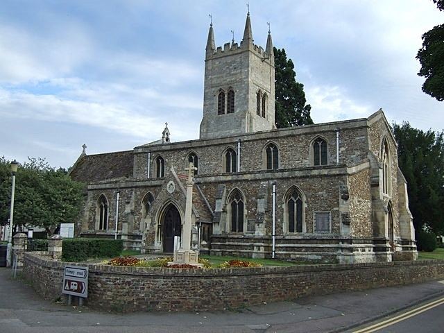
St Mary's, the parish church of Eynesbury, is mainly medieval. Parts of it show work of the Norman and all three Gothic periods; the tower is "Gothic Survival" and was built in 1687. The old east window was destroyed in ecclesiological changes to the chancel by the Victorians.
Notable people
Eynesbury was the birthplace in 1795 of James Toller, known as the Eynesbury Giant, who measured 7 feet 6 inches tall.
Sport and leisure
Eynesbury has a Non-League football club Eynesbury Rovers F.C., which play at Alfred Hall Memorial Ground.