
Country United States County Greenwood Platted 1867 Elevation 329 m Zip code 67045 | Founded 1857 Incorporated 1870 Area 5.91 km² Population 2,527 (2013) | |
 | ||
Weather 7°C, Wind S at 6 km/h, 72% Humidity | ||
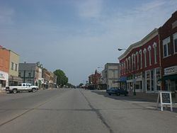
Eureka is a city and county seat of Greenwood County, Kansas, United States. As of the 2010 census, the city population was 2,633, the 2015 census estimate declined to 2,450.
Contents
- Map of Eureka KS 67045 USA
- History
- 2016 tornado
- Geography
- Climate
- 2010 census
- 2000 census
- Airport
- Area attractions
- Notable people
- Gallery
- References
Map of Eureka, KS 67045, USA
History
The first settlement at Eureka was in 1857. The first post office in Eureka was established in August 1858. Eureka was laid out in 1867, and it was incorporated in 1870. The city is named from the Greek expression Eureka, meaning "I have found it".
2016 tornado
An EF2 tornado struck Eureka on July 7, 2016 at 9:45pm. Over 143 total structures, including at least 50 homes, businesses, nursing home, and grain elevator were damaged. No persons were injured.
Geography
Eureka is located at 37°49′22″N 96°17′22″W (37.822745, -96.289583). According to the United States Census Bureau, the city has a total area of 2.28 square miles (5.91 km2), all of it land.
Climate
The climate in this area is characterized by hot, humid summers and generally mild to cool winters. According to the Köppen Climate Classification system, Eureka has a humid subtropical climate, abbreviated "Cfa" on climate maps.
2010 census
As of the census of 2010, there were 2,633 people, 1,171 households, and 663 families residing in the city. The population density was 1,154.8 inhabitants per square mile (445.9/km2). There were 1,410 housing units at an average density of 618.4 per square mile (238.8/km2). The racial makeup of the city was 95.2% White, 0.2% African American, 0.9% Native American, 0.4% Asian, 1.1% from other races, and 2.2% from two or more races. Hispanic or Latino of any race were 5.3% of the population.
There were 1,171 households of which 27.2% had children under the age of 18 living with them, 41.0% were married couples living together, 10.4% had a female householder with no husband present, 5.2% had a male householder with no wife present, and 43.4% were non-families. 39.3% of all households were made up of individuals and 18.8% had someone living alone who was 65 years of age or older. The average household size was 2.17 and the average family size was 2.86.
The median age in the city was 43.2 years. 23.7% of residents were under the age of 18; 6.9% were between the ages of 18 and 24; 21.5% were from 25 to 44; 25.5% were from 45 to 64; and 22.3% were 65 years of age or older. The gender makeup of the city was 47.9% male and 52.1% female.
2000 census
As of the census of 2000, there were 2,914 people, 1,278 households, and 756 families residing in the city. The population density was 1,490.1 people per square mile (574.0/km²). There were 1,561 housing units at an average density of 798.3 per square mile (307.5/km²). The racial makeup of the city was 96.26% White, 0.14% African American, 0.79% Native American, 0.14% Asian, 0.96% from other races, and 1.72% from two or more races. Hispanic or Latino of any race were 2.64% of the population.
There were 1,278 households out of which 26.1% had children under the age of 18 living with them, 46.2% were married couples living together, 8.8% had a female householder with no husband present, and 40.8% were non-families. 38.1% of all households were made up of individuals and 21.8% had someone living alone who was 65 years of age or older. The average household size was 2.18 and the average family size was 2.85.
In the city, the population was spread out with 23.2% under the age of 18, 7.8% from 18 to 24, 22.4% from 25 to 44, 19.4% from 45 to 64, and 27.3% who were 65 years of age or older. The median age was 42 years. For every 100 females there were 85.1 males. For every 100 females age 18 and over, there were 78.8 males.
The median income for a household in the city was $26,410, and the median income for a family was $36,667. Males had a median income of $27,066 versus $20,870 for females. The per capita income for the city was $15,142. About 9.0% of families and 14.8% of the population were below the poverty line, including 18.4% of those under age 18 and 12.3% of those age 65 or over.
Airport
Eureka Municipal Airport is a city owned, public use airport located two nautical miles (4 km) north of the central business district of Eureka.