
Population 4,628 (2011 census) LGA(s) Central Coast Council Ettalong Beach Booker Bay Postal code 2257 Federal division Division of Robertson | Postcode(s) 2257 State electorate(s) Gosford Area 170 ha Parish Patonga | |
 | ||
Location 16 km (10 mi) S of Gosford
4 km (2 mi) S of Woy Woy Similar Avoca Beach, Brisbane Water, Toowoon Bay, Erina Fair, Shelly Beach | ||
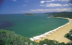
Ettalong Beach is a suburb of the Central Coast region of New South Wales, Australia south of Woy Woy on Brisbane Water at the point where it meets Broken Bay, about 80 km north of Sydney. It is part of the Central Coast Council local government area. Ettalong Beach is the natural eastward continuation of Umina Beach and Ocean Beach. The village is serviced by a small retail centre along Ocean View Road.
Contents
- Map of Ettalong Beach NSW 2257 Australia
- Business
- Transport Links
- Brisbane Water Oyster Festival
- Foreshore Upgrade
- References
Map of Ettalong Beach NSW 2257, Australia
The Mantra Ettalong Beach Resort (formerly operated by Outrigger) and Ettalong Beach War Memorial Club was completed in 2005.
A "Fast Ferry" had been proposed from Ettalong to Circular Quay, Sydney. If it had been established, the service was expected to take only 40 minutes, compared to 1 hour 15 min for the train journey from neighbouring Woy Woy to Sydney.
However, the company behind this idea became bankrupt in 2008, and the Fast Ferry Proposal was abandoned (http://www.peninsulanews.asn.au/News/08/0211/Released.asp). The ferry service was approved by Gosford City Council and remains with an active development consent so that a future operator could commence ferry services to Sydney.
Business
The Ettalong Beach retail centre is represented by the Peninsula Chamber of Commerce which is affiliated with the NSW Business Chamber. The Chamber successfully introduced the Peninsula Mainstreet Program in 1995 which instigated the heritage upgrade of the village centre. This led to the main street footpath paving and street landscaping which were undertaken through Gosford City Council's 1998 Financial Strategy resulting in the rejuvenation of the village. The main employers in the village are the Ettalong Beach Club, Mantra Resort, IGA Supermarket and Ettalong Beach Hotel. Ettalong Beach is also renowned for the Ettalong Beach Markets at the eastern end of Ocean View Road. The market complex also includes a range of restaurants and cafés together with the ornate Cinema Paradiso operated by a local family.
Transport Links
Ettalong Beach is serviced by regular bus services (Busways) with connections to Woy Woy Rail Station, the Umina Beach retail centre, Kincumber and Erina Fair. The village is also serviced by the Palm Beach Ferry which connects the town to the north shore of Sydney and provides an important tourist route for visitors to the village and commuter link to the Northern Beaches.
Brisbane Water Oyster Festival
The Brisbane Water Oyster Festival is held annually in November, on The Esplanade and the foreshore reserve. The event attracts 20,000 people annually and is organised by the Peninsula Chamber of Commerce. The event showcases the local oyster industry which is one of the earliest marine industries in Brisbane Water. The first festival was originally held at Woy Woy in 2000 but quickly outgrew its venue and was relocated to Ettalong Beach in 2005. The highly successful community festival is run by a sub-committee of the Peninsula Chamber of Commerce and chaired from its inception by the Peninsula Mainstreet Co-ordinator Debra Wales.
Foreshore Upgrade
The Ettalong Beach Foreshore Reserve upgrade was completed in early 2014 by Gosford City Council at a total cost of almost $5.4M including Federal funds of $2M. The works were a culmination of 15 years of lobbying by the Peninsula Chamber of Commerce for the upgrading of the foreshore and renourishment of Ettalong Beach. The upgraded foreshore includes children's play areas, barbecue facilities, cycle ways, landscaping and café/restaurant overlooking the beach area. The cycle way links Ettalong Beach with Umina Beach to the south.