
Country United States Area code(s) 910 Elevation 57 m Population 4,637 (2013) | State North Carolina Time zone Eastern (EST) (UTC-5) FIPS code 37-21740 Zip code 28339 Local time Tuesday 1:04 PM | |
 | ||
Weather 23°C, Wind S at 24 km/h, 40% Humidity | ||
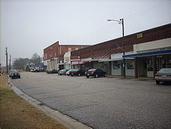
Erwin is a town in Harnett County, North Carolina, United States. The population was 4,405 at the 2010 census. Erwin is a part of the Dunn Micropolitan Area, which is also a part of the greater Raleigh–Durham–Cary Combined Statistical Area (CSA) as defined by the United States Census Bureau.
Contents
Map of Erwin, NC, USA
History
In the colonial days of Erwin, then named Duke, the town of Aversboro was built as a warsite. Over the years, Aversboro was the site of the Civil war.In 1904, the Duke family built the iconic Erwin Cotton Mill, but closed in 2000. Duke named the town after his last name, Duke. In 1925, Duke was changed to Erwin because of the formation of Duke University. Oak Grove and the Averasboro Battlefield Historic District are listed on the National Register of Historic Places.
Geography
Erwin is located at 35°19′22″N 78°40′19″W (35.322840, −78.672005).
According to the United States Census Bureau, the town has a total area of 4.1 square miles (11 km2), of which, 4.0 square miles (10 km2) of it is land and 0.04 square miles (0.10 km2) of it (0.99%) is water.
Demographics
As of the census of 2000, there were 4,537 people, 1,896 households, and 1,287 families residing in the town. The population density was 1,128.8 people per square mile (435.8/km²). There were 2,032 housing units at an average density of 505.6 per square mile (195.2/km²). The racial makeup of the town was 80.63% White, 15.96% African American, 0.55% Native American, 0.09% Asian, 1.79% from other races, and 0.99% from two or more races. Hispanic or Latino of any race were 4.14% of the population.
There were 1,896 households out of which 29.2% had children under the age of 18 living with them, 50.9% were married couples living together, 12.5% had a female householder with no husband present, and 32.1% were non-families. 28.3% of all households were made up of individuals and 14.9% had someone living alone who was 65 years of age or older. The average household size was 2.38 and the average family size was 2.90.
In the town, the population was spread out with 23.7% under the age of 18, 6.9% from 18 to 24, 27.9% from 25 to 44, 23.5% from 45 to 64, and 17.9% who were 65 years of age or older. The median age was 39 years. For every 100 females there were 90.9 males. For every 100 females age 18 and over, there were 89.0 males.
The median income for a household in the town was $29,521, and the median income for a family was $41,270. Males had a median income of $29,610 versus $22,650 for females. The per capita income for the town was $18,282. About 16.4% of families and 20.7% of the population were below the poverty line, including 22.2% of those under age 18 and 31.3% of those age 65 or over.
Erwin includes three schools: Gentry Primary, Erwin Elementary, and Triton High School.
Watersphere
In early 2012, Erwin became home to the tallest sphere-topped water tower. The 219.75 foot structure is about eight feet taller than the previous record holder, the Union Watersphere in Union, New Jersey.