
Postcode(s) 3825 Mean min temp Annual rainfall Postal code 3825 Federal division Division of McMillan | Mean max temp Mean min temp Elevation 445 m Local time Sunday 3:28 PM | |
 | ||
Weather 22°C, Wind NW at 3 km/h, 47% Humidity | ||
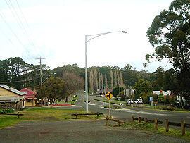
Erica is a town in Victoria, Australia, on Rawson Road, in the Shire of Baw Baw.
Map of Erica VIC 3825, Australia
The area was generally known as Upper Moondarra in the early 1900s, the township of Erica beginning to grow after construction of the railway line from Moe to Walhalla, which passed through the area. When the station opened in 1910 it was named Harris, but had been renamed Erica after a nearby mountain by 1914. As a consequence, the Post Office opened on 14 July 1910 as Upper Moondarra and was renamed Erica in 1914.
The township of Erica lived mainly from forestry and agriculture, and owing to Walhalla's decline by the 1920s was the largest town on the Moe-Walhalla railway. The section of line past Erica closed to traffic in 1944, save for occasional goods services to Platina station, and the line from Moe to Erica closed completely in 1954.
Erica still maintains agricultural and timber industry connections, as well as being a service town for local tourist destinations such as the Thomson Dam, the Walhalla Goldfields Railway, Mount Baw Baw and Mount St Gwinear.
At the 2011 census, Erica and the surrounding area had a population of 324. The newer town of Rawson is located a few kilometres away.