
Country United States County Clark FIPS code 20-21350 Elevation 600 m Zip code 67840 Population 76 (2013) | State Kansas Time zone Central (CST) (UTC-6) GNIS feature ID 0470810 Area 2.62 km² Local time Friday 2:37 PM Area code 620 | |
 | ||
Weather 6°C, Wind E at 11 km/h, 41% Humidity | ||
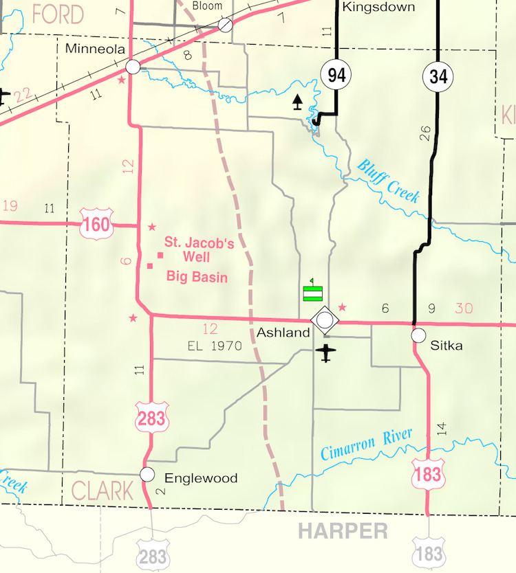
Englewood is a city in Clark County, Kansas, United States. As of the 2010 census, the city population was 77.
Contents
Map of Englewood, KS 67831, USA
History
Englewood was founded in 1884. It was named after the city of Englewood, Illinois. The first post office in Englewood was established in 1885.
In the early 20th century, Englewood was planned to become the northern terminus of the since defunct Wichita Falls and Northwestern Railway, one of the Frank Kell/Joseph A. Kemp properties based in Wichita Falls, Texas. The northern terminus was actually established in 1912 at Forgan, Oklahoma, then later rail service to Forgan ended in 1973, as Altus, Oklahoma became the northern terminus of the successor company.
Geography
Englewood is located at 37°2′10″N 99°59′16″W (37.036217, -99.987725). According to the United States Census Bureau, the city has a total area of 1.01 square miles (2.62 km2), all of it land.
2010 census
As of the census of 2010, there were 77 people, 40 households, and 20 families residing in the city. The population density was 76.2 inhabitants per square mile (29.4/km2). There were 68 housing units at an average density of 67.3 per square mile (26.0/km2). The racial makeup of the city was 88.3% White, 1.3% Asian, and 10.4% from other races. Hispanic or Latino of any race were 10.4% of the population.
There were 40 households of which 15.0% had children under the age of 18 living with them, 45.0% were married couples living together, 2.5% had a female householder with no husband present, 2.5% had a male householder with no wife present, and 50.0% were non-families. 45.0% of all households were made up of individuals and 22.5% had someone living alone who was 65 years of age or older. The average household size was 1.93 and the average family size was 2.75.
The median age in the city was 53.5 years. 19.5% of residents were under the age of 18; 0.0% were between the ages of 18 and 24; 11.7% were from 25 to 44; 36.4% were from 45 to 64; and 32.5% were 65 years of age or older. The gender makeup of the city was 59.7% male and 40.3% female.
2000 census
As of the census of 2000, there were 109 people, 49 households, and 29 families residing in the city. The population density was 108.8 people per square mile (42.1/km²). There were 62 housing units at an average density of 61.9 per square mile (23.9/km²). The racial makeup of the city was 94.50% White, 0.92% Native American, 4.59% from other races. Hispanic or Latino of any race were 6.42% of the population.
There were 49 households out of which 24.5% had children under the age of 18 living with them, 55.1% were married couples living together, 4.1% had a female householder with no husband present, and 38.8% were non-families. 34.7% of all households were made up of individuals and 18.4% had someone living alone who was 65 years of age or older. The average household size was 2.22 and the average family size was 2.90.
In the city, the population was spread out with 19.3% under the age of 18, 4.6% from 18 to 24, 18.3% from 25 to 44, 30.3% from 45 to 64, and 27.5% who were 65 years of age or older. The median age was 50 years. For every 100 females there were 131.9 males. For every 100 females age 18 and over, there were 131.6 males.
The median income for a household in the city was $22,500, and the median income for a family was $28,750. Males had a median income of $23,750 versus $0 for females. The per capita income for the city was $10,744. There were 13.3% of families and 30.3% of the population living below the poverty line, including 66.7% of under eighteens and 6.5% of those over 64.
Education
Englewood is served by USD 220 Ashland Public Schools.
Englewood High School was closed through school unification. The Englewood High School mascot was Bulldogs.