
Country United States County Solano FIPS code 06-22146 Elevation 23 m Zip code 95625 Area code Area code 707 | Time zone PST (UTC-8) GNIS feature ID 1655995 Area 138 ha Population 188 (2010) | |
 | ||
Elmira is a census-designated place (CDP) in Solano County, California, United States. The population was 188 at the 2010 census.
Contents
Map of Elmira, CA, USA
History
Elmira, California, is named after Elmira, New York.
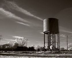
In the 19th and early 20th century, Elmira was the major railroad stop between Fairfield and Davis. To get to Vacaville, travelers had to take a spur from Elmira. When U.S. Route 40 was built through Vacaville, the population of Vacaville increased in size, while the population of Elmira declined.
Geography
According to the United States Census Bureau, the CDP has a total area of 0.531 square miles (1.38 km2), all of it land.
2010
The 2010 United States Census reported that Elmira had a population of 188. The population density was 353.9 people per square mile (136.6/km²). The racial makeup of Elmira was 150 (79.8%) White, 1 (0.5%) African American, 10 (5.3%) Native American, 2 (1.1%) Asian, 0 (0.0%) Pacific Islander, 17 (9.0%) from other races, and 8 (4.3%) from two or more races. Hispanic or Latino of any race were 47 persons (25.0%).
The Census reported that 188 people (100% of the population) lived in households, 0 (0%) lived in non-institutionalized group quarters, and 0 (0%) were institutionalized.
There were 85 households, out of which 20 (23.5%) had children under the age of 18 living in them, 34 (40.0%) were opposite-sex married couples living together, 6 (7.1%) had a female householder with no husband present, 7 (8.2%) had a male householder with no wife present. There were 6 (7.1%) unmarried opposite-sex partnerships, and 0 (0%) same-sex married couples or partnerships. 33 households (38.8%) were made up of individuals and 9 (10.6%) had someone living alone who was 65 years of age or older. The average household size was 2.21. There were 47 families (55.3% of all households); the average family size was 3.00.
The population was spread out with 34 people (18.1%) under the age of 18, 14 people (7.4%) aged 18 to 24, 49 people (26.1%) aged 25 to 44, 65 people (34.6%) aged 45 to 64, and 26 people (13.8%) who were 65 years of age or older. The median age was 43.4 years. The population was 54% male and 46% female.
There were 91 housing units at an average density of 171.3 per square mile (66.1/km²), of which 45 (52.9%) were owner-occupied, and 40 (47.1%) were occupied by renters. The homeowner vacancy rate was 0%; the rental vacancy rate was 7.0%. 101 people (53.7% of the population) lived in owner-occupied housing units and 87 people (46.3%) lived in rental housing units.
2000
As of the census of 2000, there were 205 people, 86 households, and 52 families residing in the CDP. The population density was 378.5 people per square mile (146.6/km²). There were 92 housing units at an average density of 169.8/sq mi (65.8/km²). The racial makeup of the CDP was 87.80% White, 1.46% African American, 1.46% Pacific Islander, 6.34% from other races, and 2.93% from two or more races. Hispanic or Latino of any race were 26.34% of the population.
There were 86 households out of which 27.9% had children under the age of 18 living with them, 39.5% were married couples living together, 12.8% had a female householder with no husband present, and 39.5% were non-families. 36.0% of all households were made up of individuals and 7.0% had someone living alone who was 65 years of age or older. The average household size was 2.38 and the average family size was 3.12.
In the CDP, the population was spread out with 24.9% under the age of 18, 7.8% from 18 to 24, 29.3% from 25 to 44, 29.8% from 45 to 64, and 8.3% who were 65 years of age or older. The median age was 38 years. The population was 52.7% male and 47.3% female.
The median income for a household in the CDP was $48,438, based on a sample of the population. The per capita income for the CDP was $35,397. None of the families and 7.0% of the population were living below the poverty line.